GeoScan S1 - Scan, Map and Build Smarter
GeoScan S1 - Scan, Map and Build Smarter

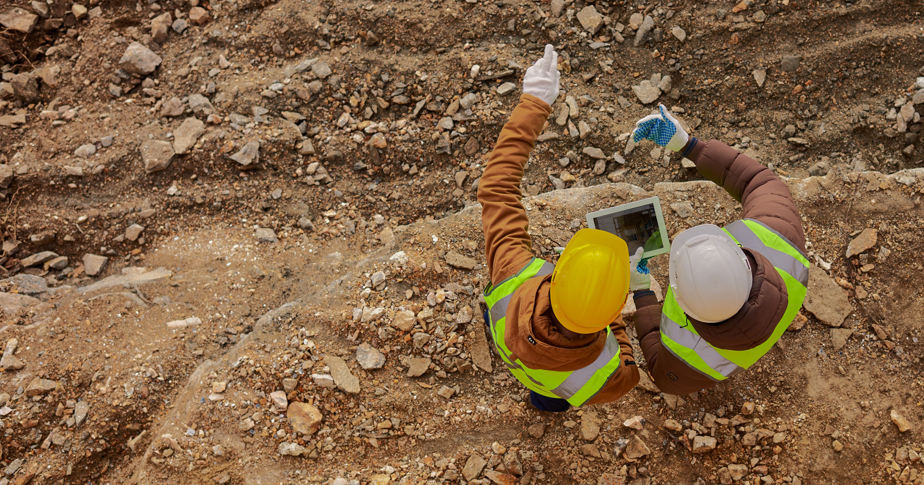
The future of construction data capture is here and it fits right in your hand. Introducing GeoScan S1, Kodifly’s high-performance handheld LiDAR scanner built to redefine how professionals scan, document, and build. Designed for teams who demand accuracy, speed, and efficiency, GeoScan S1 brings cutting-edge 3D laser scanning technology directly to the field without the complexity, bulk, or cost of traditional systems.
At its core, LiDAR works by emitting rapid laser pulses that bounce off surfaces and return to the sensor. This process measures millions of precise distances per second, creating detailed 3D point clouds that form the foundation of digital twin mapping, virtual replicas of physical spaces and assets. These digital twins are not static models; they are dynamic, data-rich environments that mirror real-world conditions with exceptional accuracy.
Across the construction lifecycle, digital twins have become invaluable.
During design validation, engineers can simulate scenarios and assess structural integrity before breaking ground.
Throughout construction, teams can monitor progress and detect deviations from design plans in real time.
For safety checks, digital twins offer immersive visualization that helps identify hazards and optimize workflows.
In maintenance and facility management, they evolve continuously, supporting predictive maintenance and efficient operations.
LiDAR and digital twin mapping have become the backbone of data-driven construction but until recently, accessibility and ease of use remained barriers to adoption.
Introducing GeoScan S1 -
Precision in the Palm of Your Hand

Meet the GeoScan S1, Kodifly’s next-generation handheld LiDAR scanner engineered to put the power of high-precision 3D scanning directly in your hands. Compact yet uncompromising, it’s designed for professionals who need accurate, real-time spatial data without the heavy equipment or complex setups.
While traditional LiDAR systems have transformed data capture, they often come with trade-offs: bulky hardware, steep learning curves, and costs that limit accessibility. GeoScan S1 changes that equation. It combines multi-sensor fusion technology, advanced SLAM algorithms, and a rugged, ergonomic design to deliver professional-grade performance anywhere whether you’re scanning a construction site, inspecting infrastructure, or capturing research environments.
What makes GeoScan S1 truly distinct is its integration of IMU, LiDAR, and RTK positioning systems through advanced SLAM (Simultaneous Localization and Mapping). This powerful combination allows seamless transitions between indoor and outdoor environments, ensuring consistent accuracy no matter the conditions. In essence, GeoScan S1 delivers professional-grade LiDAR performance in a form factor that’s compact, intuitive, and ready for real-world deployment.

Standout Features & Technology
The GeoScan S1 is built to perform where precision meets practicality. Every detail of its design serves a single purpose, to make high-quality 3D scanning faster, easier, and more accessible for professionals in the field.

Multi-Sensor Fusion SLAM
By combining LiDAR, IMU, and RTK systems, the GeoScan S1 delivers seamless and highly accurate 3D mapping in any environment, from tight indoor spaces to expansive outdoor sites.High Performance, Every Time
Capture up to 200,000 points per second with 360° coverage, a 70-meter range, and ±1.5 cm precision. It provides the level of accuracy modern construction workflows demand, without slowing you down.Effortless Operation
With its one-touch start, HD touchscreen for live previews, and instant data export, scanning and integrating results into BIM or digital twin platforms has never been easier.Lightweight and Portable
Weighing just 1.95 kg (including battery), the GeoScan S1 is designed for comfort and mobility. Its ergonomic grip and 4-hour battery life make it ideal for extended on-site work.Built to Last
A rugged IP67-rated aviation-grade aluminum body ensures reliability even in the toughest construction environments, whether it’s dust, rain, or rough handling.
The GeoScan S1 brings together power, portability, and precision, bridging the gap between professional-grade performance and everyday usability.
How Handheld Scanning Transforms Your Construction Site

1. Speed
Capture complete site conditions in minutes rather than days. The GeoScan S1 accelerates workflows, enabling teams to perform rapid surveys and progress scans without halting ongoing operations.
2. Collaboration
Share real-time 3D data instantly across teams. Architects, engineers, and project managers can collaborate remotely using the same high-resolution spatial models, eliminating communication gaps and improving decision-making.
3. Flexibility
Operate anywhere. Whether mapping confined interiors, mechanical rooms, tunnels, or open sites, the GeoScan S1 adapts effortlessly to every environment. Its handheld design offers versatility that larger systems can’t match.
4. Cost Efficiency
Reduce rework, material waste, and delays. Accurate point cloud data helps detect design clashes early, optimize material usage, and maintain quality control, saving both time and budget throughout the project lifecycle.
Construction Site Applications

Construction Progress Monitoring
Conduct frequent scans to track on-site progress, compare actual conditions with BIM models, and identify deviations early. The GeoScan S1 enables proactive quality management and schedule optimization.Safety & Compliance
Enhance workplace safety and simplify compliance documentation. Capture accurate 3D measurements of site conditions and safety installations without exposing staff to hazards.Quick Site Surveys
Perform fast, high-accuracy surveys during early project stages or emergency responses. Document existing conditions in hours instead of days, ideal for renovation or feasibility studies.Volume Calculation
Accurately calculate excavation volumes, stockpile quantities, and material usage using 3D laser scanning. Improve resource allocation and minimize waste.Education & Research
Empower academic institutions and research labs with affordable access to professional-grade LiDAR tools. Support hands-on learning and spatial data research across engineering, architecture, and archaeology.
Precision. Performance. Portability.
GeoScan S1 brings professional-grade LiDAR scanning to every site. Capture high-resolution 3D data in seconds and turn real-world spaces into detailed digital twins, all from the palm of your hand.
Order the GeoScan S1 now and experience unmatched accuracy, speed, and portability in every scan.
Bring GeoScan S1 to your next project,
Buy now and start scanning smarter.
The future of construction data capture is here and it fits right in your hand. Introducing GeoScan S1, Kodifly’s high-performance handheld LiDAR scanner built to redefine how professionals scan, document, and build. Designed for teams who demand accuracy, speed, and efficiency, GeoScan S1 brings cutting-edge 3D laser scanning technology directly to the field without the complexity, bulk, or cost of traditional systems.
At its core, LiDAR works by emitting rapid laser pulses that bounce off surfaces and return to the sensor. This process measures millions of precise distances per second, creating detailed 3D point clouds that form the foundation of digital twin mapping, virtual replicas of physical spaces and assets. These digital twins are not static models; they are dynamic, data-rich environments that mirror real-world conditions with exceptional accuracy.
Across the construction lifecycle, digital twins have become invaluable.
During design validation, engineers can simulate scenarios and assess structural integrity before breaking ground.
Throughout construction, teams can monitor progress and detect deviations from design plans in real time.
For safety checks, digital twins offer immersive visualization that helps identify hazards and optimize workflows.
In maintenance and facility management, they evolve continuously, supporting predictive maintenance and efficient operations.
LiDAR and digital twin mapping have become the backbone of data-driven construction but until recently, accessibility and ease of use remained barriers to adoption.
Introducing GeoScan S1 -
Precision in the Palm of Your Hand
Meet the GeoScan S1, Kodifly’s next-generation handheld LiDAR scanner engineered to put the power of high-precision 3D scanning directly in your hands. Compact yet uncompromising, it’s designed for professionals who need accurate, real-time spatial data without the heavy equipment or complex setups.
While traditional LiDAR systems have transformed data capture, they often come with trade-offs: bulky hardware, steep learning curves, and costs that limit accessibility. GeoScan S1 changes that equation. It combines multi-sensor fusion technology, advanced SLAM algorithms, and a rugged, ergonomic design to deliver professional-grade performance anywhere whether you’re scanning a construction site, inspecting infrastructure, or capturing research environments.
What makes GeoScan S1 truly distinct is its integration of IMU, LiDAR, and RTK positioning systems through advanced SLAM (Simultaneous Localization and Mapping). This powerful combination allows seamless transitions between indoor and outdoor environments, ensuring consistent accuracy no matter the conditions. In essence, GeoScan S1 delivers professional-grade LiDAR performance in a form factor that’s compact, intuitive, and ready for real-world deployment.
Standout Features & Technology
The GeoScan S1 is built to perform where precision meets practicality. Every detail of its design serves a single purpose, to make high-quality 3D scanning faster, easier, and more accessible for professionals in the field.
Multi-Sensor Fusion SLAM
By combining LiDAR, IMU, and RTK systems, the GeoScan S1 delivers seamless and highly accurate 3D mapping in any environment, from tight indoor spaces to expansive outdoor sites.High Performance, Every Time
Capture up to 200,000 points per second with 360° coverage, a 70-meter range, and ±1.5 cm precision. It provides the level of accuracy modern construction workflows demand, without slowing you down.Effortless Operation
With its one-touch start, HD touchscreen for live previews, and instant data export, scanning and integrating results into BIM or digital twin platforms has never been easier.Lightweight and Portable
Weighing just 1.95 kg (including battery), the GeoScan S1 is designed for comfort and mobility. Its ergonomic grip and 4-hour battery life make it ideal for extended on-site work.Built to Last
A rugged IP67-rated aviation-grade aluminum body ensures reliability even in the toughest construction environments, whether it’s dust, rain, or rough handling.
The GeoScan S1 brings together power, portability, and precision, bridging the gap between professional-grade performance and everyday usability.
How Handheld Scanning Transforms Your Construction Site
1. Speed
Capture complete site conditions in minutes rather than days. The GeoScan S1 accelerates workflows, enabling teams to perform rapid surveys and progress scans without halting ongoing operations.
2. Collaboration
Share real-time 3D data instantly across teams. Architects, engineers, and project managers can collaborate remotely using the same high-resolution spatial models, eliminating communication gaps and improving decision-making.
3. Flexibility
Operate anywhere. Whether mapping confined interiors, mechanical rooms, tunnels, or open sites, the GeoScan S1 adapts effortlessly to every environment. Its handheld design offers versatility that larger systems can’t match.
4. Cost Efficiency
Reduce rework, material waste, and delays. Accurate point cloud data helps detect design clashes early, optimize material usage, and maintain quality control, saving both time and budget throughout the project lifecycle.
Construction Site Applications
Construction Progress Monitoring
Conduct frequent scans to track on-site progress, compare actual conditions with BIM models, and identify deviations early. The GeoScan S1 enables proactive quality management and schedule optimization.Safety & Compliance
Enhance workplace safety and simplify compliance documentation. Capture accurate 3D measurements of site conditions and safety installations without exposing staff to hazards.Quick Site Surveys
Perform fast, high-accuracy surveys during early project stages or emergency responses. Document existing conditions in hours instead of days, ideal for renovation or feasibility studies.Volume Calculation
Accurately calculate excavation volumes, stockpile quantities, and material usage using 3D laser scanning. Improve resource allocation and minimize waste.Education & Research
Empower academic institutions and research labs with affordable access to professional-grade LiDAR tools. Support hands-on learning and spatial data research across engineering, architecture, and archaeology.
Precision. Performance. Portability.
GeoScan S1 brings professional-grade LiDAR scanning to every site. Capture high-resolution 3D data in seconds and turn real-world spaces into detailed digital twins, all from the palm of your hand.
Order the GeoScan S1 now and experience unmatched accuracy, speed, and portability in every scan.
Bring GeoScan S1 to your next project,
Buy now and start scanning smarter.
Table of Content
Oct 10, 2025
Interested to find out how Kodifly transforms the infrastructure space?

Revolutionizing Site Supervision Powered by SpatialSense’s Site Diary Feature
Mar 2, 2026

10 Construction Site Operations Powered by SpatialSense
Jan 29, 2026
Who Can Benefit from SpatialSense and How?
Dec 30, 2025

Smarter O&M with Temperature Data & Digital Twins
Nov 28, 2025