Who Can Benefit from SpatialSense and How?
Who Can Benefit from SpatialSense and How?
Modern construction and infrastructure projects move fast and operate at scale. They demand real-time visibility, seamless collaboration, and a single source of truth. Yet many teams still rely on fragmented tools - spreadsheets, static drawings, PDFs, and long email threads.
The result?
Delayed decisions, rework, misalignment between teams, and limited control over what’s actually happening on site.
SpatialSense by Kodifly changes that by bringing real-time intelligence, clarity, and control to every stage of your project.
SpatialSense is an AI-powered infrastructure management platform that brings together point cloud data (PCD), BIM models, IoT inputs, and team collaboration into one unified environment. Instead of working in silos, teams can virtually walk the site, track progress, validate work, and identify issues early, before they impact timelines or budgets.
Construction Project Managers
Construction project managers oversee schedules, budgets, and coordination across the whole site. SpatialSense helps them stay on top of everything by:
Real-time site visibility: Continuous scans (from drones or fixed sensors) updates a 3D model of the site, so managers can track progress and spot issues immediately.
Early issue alerts: Flag deviations (like misaligned structures or unfinished sections) so problems are caught before they become costly. This proactive tracking comes from automated 3D progress reports and dashboards.
Centralized information: All notes, reports, and observations live in one platform. Instead of juggling spreadsheets, emails, and drawings, everyone looks at the same digital twin. This single source of truth cuts down miscommunications and keeps teams in sync.
Faster decisions & fewer delays: With instant insights, decision makers can assign fixes and approvals on the spot. SpatialSense shows exactly what’s happening, reducing guesswork and rework so projects stay on schedule.
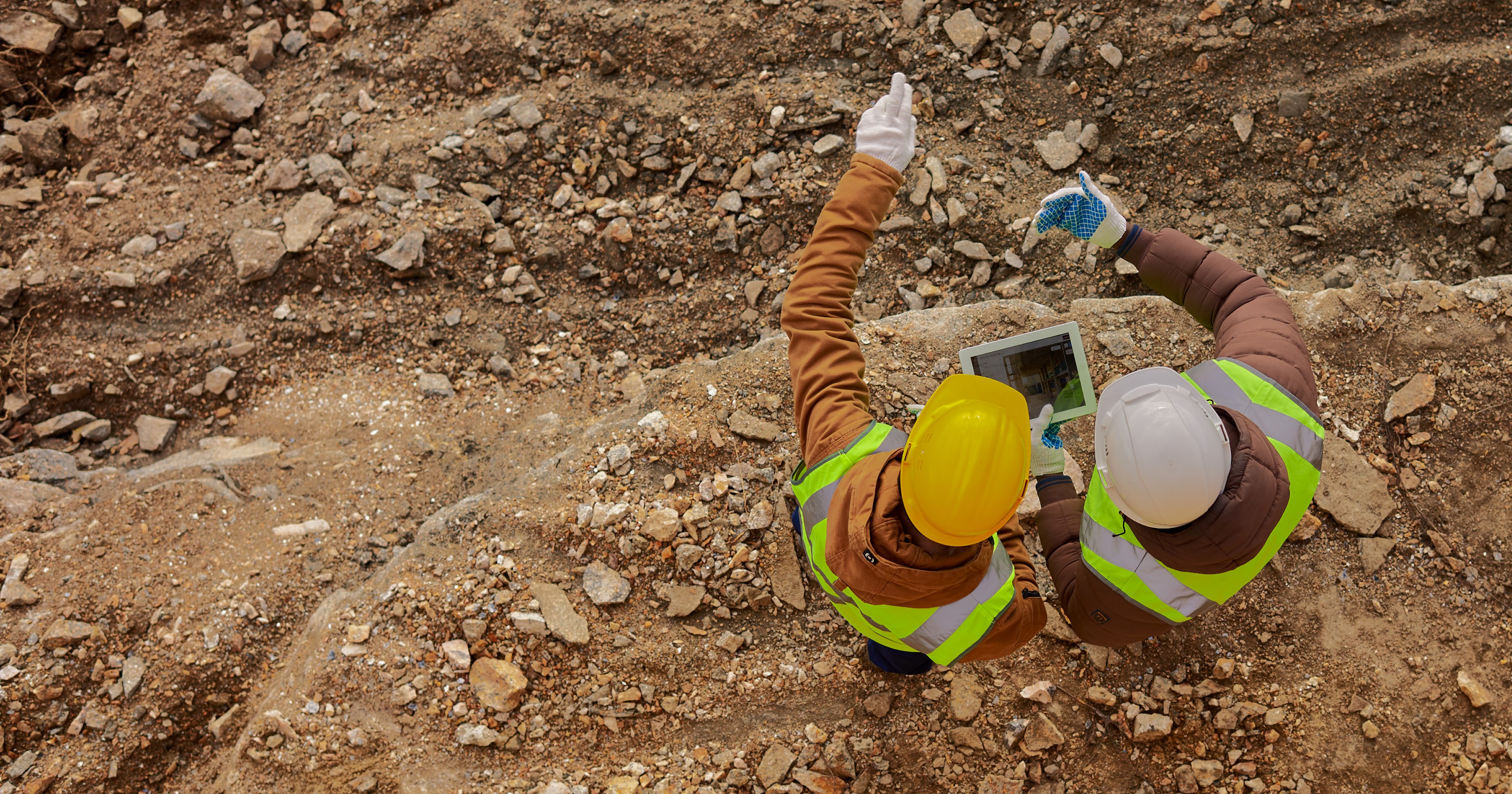
Field Engineers & Surveyors
Field engineers and surveyors spend their days capturing on-site measurements and verifying that the build matches the plans. SpatialSense makes their job easier by:
Instant 3D modeling: Drone imagery and LiDAR scans are automatically converted into a detailed 3D site model. You capture the field once, and the digital twin is ready for everyone.
Remote inspection & measurement: Engineers can review the virtual site from the office or truck – pulling precise distances, areas, and volumes right out of the point-cloud model. This cuts down needless travel because one scan can be used for countless checks.
Higher efficiency: Automating the scan-to-model process means less manual surveying. Once the data is in SpatialSense, it’s reused across tasks, so you’re not redoing the same measurements over and over.
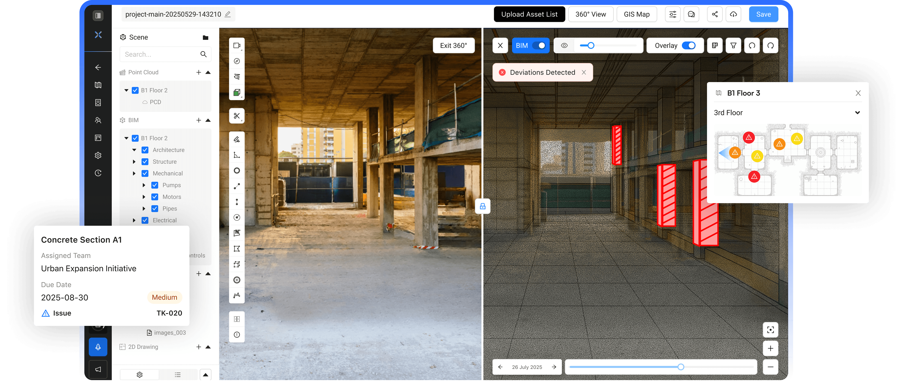
BIM & Design Engineers
BIM and design teams create the digital plans and want to ensure construction follows those designs. SpatialSense bridges design and reality:
As-built vs. design checks: Live site scans are overlaid on the BIM model, instantly highlighting clashes or deviations. You’ll see if an element is off by even a small amount compared to the plans.
Always-current models: Regular scans refresh the digital twin, so your model stays in sync with the jobsite. This “living” model means designers catch changes (like site modifications or unforeseen obstacles) right away.
Collaborative reviews: Rather than e-mailing outdated PDFs, everyone uses the same 3D context. Designers, contractors, and owners can tag issues or RFIs directly on the model and discuss them in place. This visual, shared environment speeds up approvals and avoids lengthy back-and-forth.
Safety & Compliance Officers
Safety officers enforce regulations and document inspections. SpatialSense gives them enhanced oversight through continuous monitoring:
Proactive hazard alerts: The live 3D twin can flag unsafe conditions as they appear (for example, an unguarded edge or unauthorized personnel entering a restricted zone). AI-driven checks on the model surface potential risks so you can address them immediately.
Automated compliance checks: The system can automatically verify that safety measures (like scaffolding setups, signage, or barrier placements) meet your standards. This cuts down manual checklist work and ensures nothing is overlooked.
Audit-ready documentation: Every inspection note or safety observation is time-stamped and linked to the exact spot on the digital twin. At audit time, you have a complete, geo-tagged record of what was checked and when, simplifying reporting.
Asset Managers & Maintenance Teams
Asset managers track equipment, installed components, and plan future upkeep. With SpatialSense they benefit by:
Live asset inventory: As construction progresses, every installed element (pipes, HVAC units, etc.) is logged in the 3D twin with its location and installation date. You always know what’s on site and where it is.
Predictive maintenance: Continuous scan data lets the platform identify wear or misalignment trends early. SpatialSense can even predict maintenance needs before failures occur, so you can schedule fixes during convenient windows.
Clean handover: Because SpatialSense has been tracking installations and inspections all along, handing over to operations becomes smoother. Owners receive a rich as-built record of assets and their history, reducing surprises and lowering long-term maintenance costs.
Contractors & Subcontractors (Field Crews)
Field crews carry out the day-to-day construction tasks. SpatialSense makes their work clearer:
Location-based instructions: Issues or tasks are tagged directly on the 3D model at the exact worksite location. Instead of vague notes or rolled-up plans, crews see exactly where to focus and what needs doing.
Mobile access: Crews use tablets or smartphones on site to pull up the latest drawings, notes, and markups on the model. This instant access replaces paper prints and reduces the chance of using outdated information.
Fewer miscommunications: Because everyone views the same visual model, verbal instructions become crystal-clear. There’s less “he-said-she-said” confusion when all teams – including you – see identical 3D context. The result is fewer errors and less rework.
Project Owners & Executives
Project owners and executives need high-level oversight and assurance. SpatialSense gives them:
Executive dashboards: Stakeholders get real-time dashboards showing overall progress, cost burn, and risk metrics. Key figures are updated automatically, so there’s no waiting on weekly status reports – the project’s health is visible at a glance.
Data-driven decisions: Up-to-date metrics and visual reports mean you can make strategic choices immediately. If an issue pops up, you have the evidence in hand to reallocate budget or resources confidently.
Stronger ROI: By catching issues early and keeping teams aligned, SpatialSense drives down delays and errors. The thorough as-built data and audit trail also protect long-term value, since the assets and their history are well-documented from day one.
In a world where infrastructure projects are growing larger, faster, and more complex, visibility and alignment are no longer optional—they’re critical. SpatialSense connects every role, from field teams to leadership, through a shared view of on-site reality. By unifying design, data, and execution, it drives faster decisions, clearer accountability, and stronger outcomes across the project lifecycle.
See it in action—request a free SpatialSense demo today.
Modern construction and infrastructure projects move fast and operate at scale. They demand real-time visibility, seamless collaboration, and a single source of truth. Yet many teams still rely on fragmented tools - spreadsheets, static drawings, PDFs, and long email threads.
The result?
Delayed decisions, rework, misalignment between teams, and limited control over what’s actually happening on site.
SpatialSense by Kodifly changes that by bringing real-time intelligence, clarity, and control to every stage of your project.
SpatialSense is an AI-powered infrastructure management platform that brings together point cloud data (PCD), BIM models, IoT inputs, and team collaboration into one unified environment. Instead of working in silos, teams can virtually walk the site, track progress, validate work, and identify issues early, before they impact timelines or budgets.
Construction Project Managers
Construction project managers oversee schedules, budgets, and coordination across the whole site. SpatialSense helps them stay on top of everything by:
Real-time site visibility: Continuous scans (from drones or fixed sensors) updates a 3D model of the site, so managers can track progress and spot issues immediately.
Early issue alerts: Flag deviations (like misaligned structures or unfinished sections) so problems are caught before they become costly. This proactive tracking comes from automated 3D progress reports and dashboards.
Centralized information: All notes, reports, and observations live in one platform. Instead of juggling spreadsheets, emails, and drawings, everyone looks at the same digital twin. This single source of truth cuts down miscommunications and keeps teams in sync.
Faster decisions & fewer delays: With instant insights, decision makers can assign fixes and approvals on the spot. SpatialSense shows exactly what’s happening, reducing guesswork and rework so projects stay on schedule.
Field Engineers & Surveyors
Field engineers and surveyors spend their days capturing on-site measurements and verifying that the build matches the plans. SpatialSense makes their job easier by:
Instant 3D modeling: Drone imagery and LiDAR scans are automatically converted into a detailed 3D site model. You capture the field once, and the digital twin is ready for everyone.
Remote inspection & measurement: Engineers can review the virtual site from the office or truck – pulling precise distances, areas, and volumes right out of the point-cloud model. This cuts down needless travel because one scan can be used for countless checks.
Higher efficiency: Automating the scan-to-model process means less manual surveying. Once the data is in SpatialSense, it’s reused across tasks, so you’re not redoing the same measurements over and over.
BIM & Design Engineers
BIM and design teams create the digital plans and want to ensure construction follows those designs. SpatialSense bridges design and reality:
As-built vs. design checks: Live site scans are overlaid on the BIM model, instantly highlighting clashes or deviations. You’ll see if an element is off by even a small amount compared to the plans.
Always-current models: Regular scans refresh the digital twin, so your model stays in sync with the jobsite. This “living” model means designers catch changes (like site modifications or unforeseen obstacles) right away.
Collaborative reviews: Rather than e-mailing outdated PDFs, everyone uses the same 3D context. Designers, contractors, and owners can tag issues or RFIs directly on the model and discuss them in place. This visual, shared environment speeds up approvals and avoids lengthy back-and-forth.
Safety & Compliance Officers
Safety officers enforce regulations and document inspections. SpatialSense gives them enhanced oversight through continuous monitoring:
Proactive hazard alerts: The live 3D twin can flag unsafe conditions as they appear (for example, an unguarded edge or unauthorized personnel entering a restricted zone). AI-driven checks on the model surface potential risks so you can address them immediately.
Automated compliance checks: The system can automatically verify that safety measures (like scaffolding setups, signage, or barrier placements) meet your standards. This cuts down manual checklist work and ensures nothing is overlooked.
Audit-ready documentation: Every inspection note or safety observation is time-stamped and linked to the exact spot on the digital twin. At audit time, you have a complete, geo-tagged record of what was checked and when, simplifying reporting.
Asset Managers & Maintenance Teams
Asset managers track equipment, installed components, and plan future upkeep. With SpatialSense they benefit by:
Live asset inventory: As construction progresses, every installed element (pipes, HVAC units, etc.) is logged in the 3D twin with its location and installation date. You always know what’s on site and where it is.
Predictive maintenance: Continuous scan data lets the platform identify wear or misalignment trends early. SpatialSense can even predict maintenance needs before failures occur, so you can schedule fixes during convenient windows.
Clean handover: Because SpatialSense has been tracking installations and inspections all along, handing over to operations becomes smoother. Owners receive a rich as-built record of assets and their history, reducing surprises and lowering long-term maintenance costs.
Contractors & Subcontractors (Field Crews)
Field crews carry out the day-to-day construction tasks. SpatialSense makes their work clearer:
Location-based instructions: Issues or tasks are tagged directly on the 3D model at the exact worksite location. Instead of vague notes or rolled-up plans, crews see exactly where to focus and what needs doing.
Mobile access: Crews use tablets or smartphones on site to pull up the latest drawings, notes, and markups on the model. This instant access replaces paper prints and reduces the chance of using outdated information.
Fewer miscommunications: Because everyone views the same visual model, verbal instructions become crystal-clear. There’s less “he-said-she-said” confusion when all teams – including you – see identical 3D context. The result is fewer errors and less rework.
Project Owners & Executives
Project owners and executives need high-level oversight and assurance. SpatialSense gives them:
Executive dashboards: Stakeholders get real-time dashboards showing overall progress, cost burn, and risk metrics. Key figures are updated automatically, so there’s no waiting on weekly status reports – the project’s health is visible at a glance.
Data-driven decisions: Up-to-date metrics and visual reports mean you can make strategic choices immediately. If an issue pops up, you have the evidence in hand to reallocate budget or resources confidently.
Stronger ROI: By catching issues early and keeping teams aligned, SpatialSense drives down delays and errors. The thorough as-built data and audit trail also protect long-term value, since the assets and their history are well-documented from day one.
In a world where infrastructure projects are growing larger, faster, and more complex, visibility and alignment are no longer optional—they’re critical. SpatialSense connects every role, from field teams to leadership, through a shared view of on-site reality. By unifying design, data, and execution, it drives faster decisions, clearer accountability, and stronger outcomes across the project lifecycle.
See it in action—request a free SpatialSense demo today.
Table of Content
Dec 30, 2025
Interested to find out how Kodifly transforms the infrastructure space?

Revolutionizing Site Supervision Powered by SpatialSense’s Site Diary Feature
Mar 2, 2026

10 Construction Site Operations Powered by SpatialSense
Jan 29, 2026
Who Can Benefit from SpatialSense and How?
Dec 30, 2025

Smarter O&M with Temperature Data & Digital Twins
Nov 28, 2025