Building Durable Roads with Kodifly’s Research-Backed Asset Monitoring
Building Durable Roads with Kodifly’s Research-Backed Asset Monitoring

Maintaining safe, durable roads is a critical challenge worldwide. According to the World Bank, inadequate road maintenance costs countries up to 5% of GDP annually, while traditional manual inspections are slow, labor-intensive, and prone to human error. Kodifly’s Road Scanning and Asset Mapping Solution addresses these challenges by leveraging advanced spatial technologies to provide accurate, actionable insights at scale.
Advanced Technology for Reliable Insights
Kodifly’s solution integrates LiDAR, high-resolution imaging, and multi-sensor data acquisition to continuously capture road conditions and asset information. Research shows that mobile mapping systems can deliver data accuracy within 10–20 mm, comparable to stationary surveys, while scanning roads at speeds exceeding 80 km/h, significantly reducing operational costs (National Land Survey of Finland, 2025).
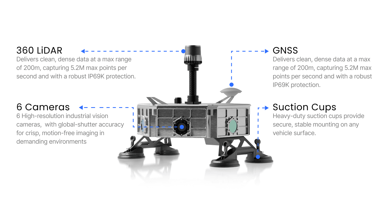
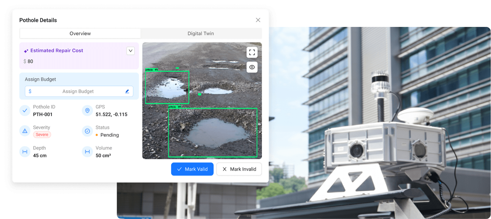
Data is processed through SpatialSense Edge, converting raw measurements into structured information that identifies pavement distress (cracks, potholes), asset conditions (signage, barriers, guardrails), and environmental risks (vegetation encroachment, drainage issues). This process transforms a survey vehicle into a moving data collection hub, with AI-powered analytics automatically detecting road conditions and infrastructure assets.
Key Features and Proven Benefits
Dashboard Management
A centralized platform visualizes road conditions and asset health in real time, improving decision-making efficiency by up to 40% (Journal of Infrastructure Systems, 2022).
Asset Inventory Management
Automatically catalogs all road assets in 3D, ensuring compliance and proactive maintenance planning. Such comprehensive inventories reduce unexpected failures by 25–30%.
Patrol Monitoring
Supports real-time monitoring of field teams and inspections, enhancing oversight and safety.
Work Order Management
Streamlines maintenance workflows by directly linking defects to actionable work orders, minimizing delays and miscommunication.
Predictive Maintenance
Uses collected data to forecast deterioration and schedule repairs before failures occur, which can extend road lifespan by 20–30% (Transportation Research Board, 2023).
Defect Detection
Employs LiDAR and AI to identify cracks, potholes, rutting, and other defects automatically, improving accuracy and reducing dependence on manual surveys.
Cost Estimation
Generates data-driven maintenance cost projections to enable efficient budget allocation and intervention prioritization.

From Data to Decisions
Kodifly’s Road Scanning and Asset Mapping Solution transforms road management from reactive to predictive, efficient, and evidence-based. By integrating advanced mobile mapping with intelligent asset management, transportation authorities gain the insights needed to make safer, smarter, and more cost-effective decisions.
The solution’s multi-sensor configuration including 360° LiDAR, high-definition cameras, GNSS, and inertial measurement units delivers dense, survey-grade 3D data in real time, creating precise georeferenced digital twins of road environments. This rich dataset supports maintenance planning, infrastructure upgrades, compliance reporting, and smart city initiatives.
Mounted on vehicles, Kodifly’s SpatialSense360 Mobile Mapping System enables inspections at normal traffic speeds, minimizing disruption and enhancing worker safety. Its AI-driven analytics and quality control pipelines ensure ministry-grade output for reliable assessments.
As road networks face increasing demands and complexity, Kodifly’s data-driven, AI-empowered approach paves the way for resilient, connected infrastructure ecosystems, helping cities and regions keep pace with modern mobility needs and sustainability goals.
Ready to revolutionize your road infrastructure management with cutting-edge technology? Discover how Kodifly’s AI-powered road scanning and asset monitoring solution can help you make smarter, data-driven decisions that enhance safety, reduce costs, and extend the life of your roads.
Contact us today to schedule a demo or learn more about how Kodifly can transform your road maintenance strategy for a smarter, safer future.
Maintaining safe, durable roads is a critical challenge worldwide. According to the World Bank, inadequate road maintenance costs countries up to 5% of GDP annually, while traditional manual inspections are slow, labor-intensive, and prone to human error. Kodifly’s Road Scanning and Asset Mapping Solution addresses these challenges by leveraging advanced spatial technologies to provide accurate, actionable insights at scale.
Advanced Technology for Reliable Insights
Kodifly’s solution integrates LiDAR, high-resolution imaging, and multi-sensor data acquisition to continuously capture road conditions and asset information. Research shows that mobile mapping systems can deliver data accuracy within 10–20 mm, comparable to stationary surveys, while scanning roads at speeds exceeding 80 km/h, significantly reducing operational costs (National Land Survey of Finland, 2025).
Data is processed through SpatialSense Edge, converting raw measurements into structured information that identifies pavement distress (cracks, potholes), asset conditions (signage, barriers, guardrails), and environmental risks (vegetation encroachment, drainage issues). This process transforms a survey vehicle into a moving data collection hub, with AI-powered analytics automatically detecting road conditions and infrastructure assets.
Key Features and Proven Benefits
Dashboard Management
A centralized platform visualizes road conditions and asset health in real time, improving decision-making efficiency by up to 40% (Journal of Infrastructure Systems, 2022).
Asset Inventory Management
Automatically catalogs all road assets in 3D, ensuring compliance and proactive maintenance planning. Such comprehensive inventories reduce unexpected failures by 25–30%.
Patrol Monitoring
Supports real-time monitoring of field teams and inspections, enhancing oversight and safety.
Work Order Management
Streamlines maintenance workflows by directly linking defects to actionable work orders, minimizing delays and miscommunication.
Predictive Maintenance
Uses collected data to forecast deterioration and schedule repairs before failures occur, which can extend road lifespan by 20–30% (Transportation Research Board, 2023).
Defect Detection
Employs LiDAR and AI to identify cracks, potholes, rutting, and other defects automatically, improving accuracy and reducing dependence on manual surveys.
Cost Estimation
Generates data-driven maintenance cost projections to enable efficient budget allocation and intervention prioritization.
From Data to Decisions
Kodifly’s Road Scanning and Asset Mapping Solution transforms road management from reactive to predictive, efficient, and evidence-based. By integrating advanced mobile mapping with intelligent asset management, transportation authorities gain the insights needed to make safer, smarter, and more cost-effective decisions.
The solution’s multi-sensor configuration including 360° LiDAR, high-definition cameras, GNSS, and inertial measurement units delivers dense, survey-grade 3D data in real time, creating precise georeferenced digital twins of road environments. This rich dataset supports maintenance planning, infrastructure upgrades, compliance reporting, and smart city initiatives.
Mounted on vehicles, Kodifly’s SpatialSense360 Mobile Mapping System enables inspections at normal traffic speeds, minimizing disruption and enhancing worker safety. Its AI-driven analytics and quality control pipelines ensure ministry-grade output for reliable assessments.
As road networks face increasing demands and complexity, Kodifly’s data-driven, AI-empowered approach paves the way for resilient, connected infrastructure ecosystems, helping cities and regions keep pace with modern mobility needs and sustainability goals.
Ready to revolutionize your road infrastructure management with cutting-edge technology? Discover how Kodifly’s AI-powered road scanning and asset monitoring solution can help you make smarter, data-driven decisions that enhance safety, reduce costs, and extend the life of your roads.
Contact us today to schedule a demo or learn more about how Kodifly can transform your road maintenance strategy for a smarter, safer future.
Table of Content
Nov 11, 2025
Interested to find out how Kodifly transforms the infrastructure space?

Revolutionizing Site Supervision Powered by SpatialSense’s Site Diary Feature
Mar 2, 2026

10 Construction Site Operations Powered by SpatialSense
Jan 29, 2026
Who Can Benefit from SpatialSense and How?
Dec 30, 2025

Smarter O&M with Temperature Data & Digital Twins
Nov 28, 2025