Building Safer and Smarter Highways with Mobile Mapping
Building Safer and Smarter Highways with Mobile Mapping

Highways are the backbone of any economy. From moving people to transporting goods, they act as the vital link that connects every opportunity. With growing demands on infrastructure and ever-increasing volumes of traffic, the pressure on highway authorities to ensure smooth, safe, and reliable journeys has never been greater.
But traditional methods of highway surveying and asset monitoring are struggling to keep pace. Manual inspections are slow, costly, and often put workers at risk, while outdated data collection leads to delayed maintenance and overlooked safety hazards. To meet today’s challenges, the industry needs a smarter, faster, and safer approach to highway management.
What is a Mobile Mapping System?
A Mobile Mapping System (MMS) is a vehicle-mounted solution that captures high-resolution spatial data while moving at normal traffic speeds. Equipped with LiDAR, cameras, and advanced sensors, the system scans highways in real time, creating precise 3D maps and digital records of every asset and surface condition.
Unlike traditional surveying methods that require lane closures, large teams, and long hours on-site, MMS allows authorities to collect more accurate data in less time without disrupting traffic flow. The result is a safer, faster, and more efficient way to monitor and manage critical highway infrastructure.
Kodifly’s Mobile Mapping System: SS-360
At Kodifly, we’ve designed the Mobile Mapping System SS-360 to meet the complex demands of modern highway infrastructure. The SS-360 combines multiple advanced sensors into a single, powerful unit, delivering complete and reliable spatial data coverage in every survey.
Equipped with:
High-precision LiDAR for dense 3D point clouds, capturing pavement details and roadside assets with full 360-degree coverage.
Six synchronized cameras providing panoramic, high-resolution imagery for complete visual documentation of the highway environment.
Inertial Measurement Unit (IMU) ensuring motion stability and accurate data capture even on uneven road surfaces.
Global Navigation Satellite System (GNSS) delivering precise georeferencing and positioning across long stretches of highway.
This fusion of technologies enables the SS-360 to capture rich, geo-referenced datasets in real time, even at normal driving speeds. Whether it’s detecting pavement defects, mapping roadside assets, or ensuring compliance with safety standards, the SS-360 delivers the precision and scalability highway operators need to make smarter decisions.
Learn more about it here.
How It Works
Our SpatialSense Mobile Mapping System (SS-360) transforms a survey vehicle into a moving data collection hub. The process can be broken down into three simple steps:
Data Capture
Mounted on a car or specialized survey vehicle, the MMS uses LiDAR scanners, cameras, and GNSS/IMU positioning systems to capture every detail of the highway environment while driving at normal speeds.
Processing & Analysis
The collected data is processed and synchronized, combining LiDAR point clouds with high-resolution imagery. With AI-powered analytics, the system automatically detects road conditions, signage, barriers, and other highway assets.
Output & Insights
The result is an accurate 3D map and digital record of the entire highway stretch ready to be integrated into GIS or BIM platforms. Operators gain a complete asset inventory and condition assessment that supports proactive maintenance planning.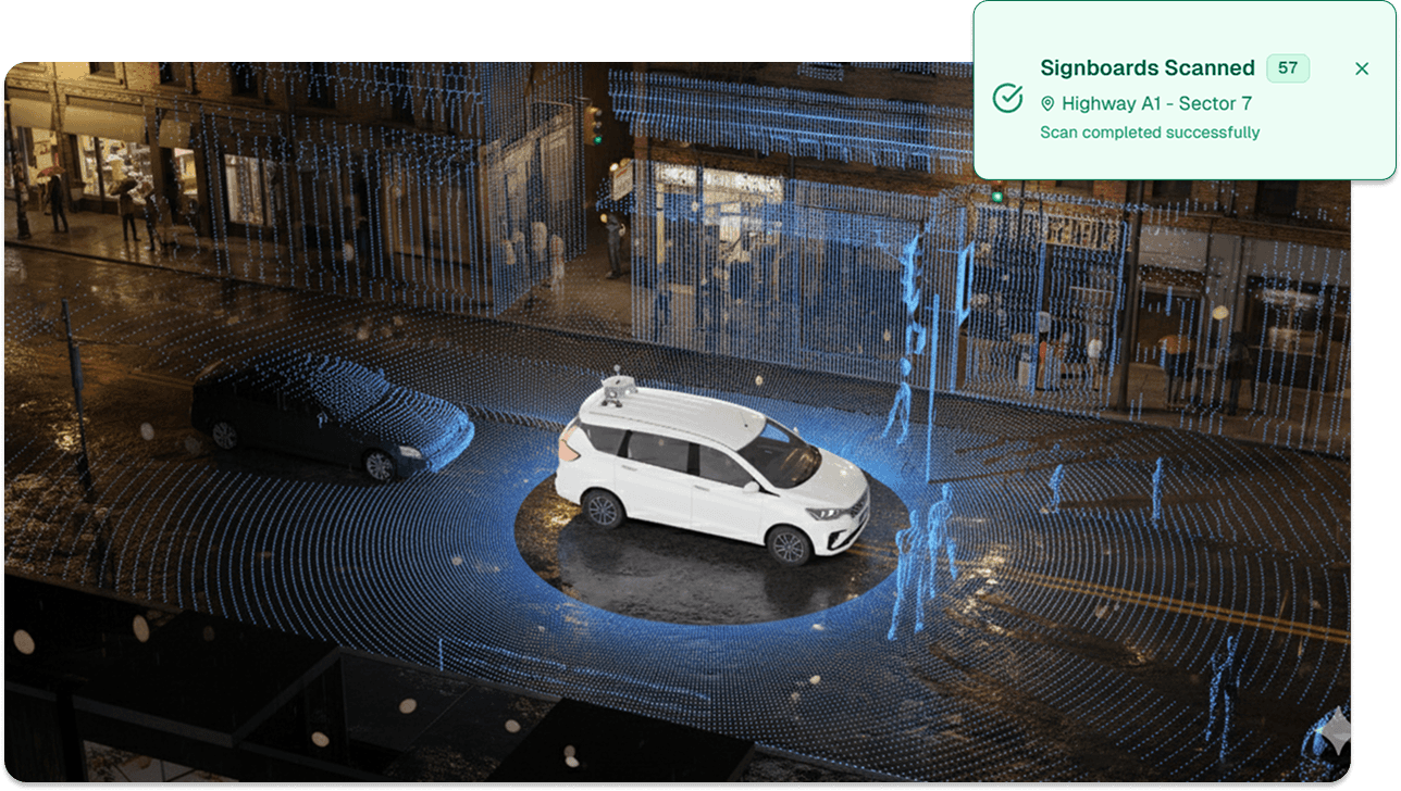
Key Highway Applications
From detecting hidden defects to ensuring compliance with safety standards, our Mobile Mapping System gives highway operators a complete and reliable view of their networks. With high-resolution data captured at scale, MMS unlocks several critical applications:
Asset Inventory
Build a digital record of highway infrastructure; signboards, lighting poles, guardrails, and lane markings, making asset management more transparent and efficient.Road Condition Monitoring
Detect cracks, potholes, rutting, and surface wear early, helping operators prioritize repairs before they disrupt traffic or escalate into costly projects.Vegetation & Roadside Management
Identify and track vegetation growth that may obstruct signage, reduce visibility, or pose safety hazards for motorists.Safety & Compliance Checks
Assess the condition and placement of barriers, signage visibility, and clearance levels to ensure highways meet regulatory and safety standards.
Shaping the Future of Highway Management
As highways continue to carry heavier demands, traditional methods of surveying and monitoring are no longer enough. Mobile Mapping Systems like Kodifly’s SS-360 bring a new standard of speed, safety, and precision helping operators build smarter maintenance strategies, reduce costs, and keep roads safer for everyone.
By combining LiDAR, multi-camera vision, GNSS, and AI-powered analytics, the SS-360 delivers the complete picture highway authorities need to move from reactive repairs to proactive infrastructure management.
The future of highways lies in data-driven decision-making and with mobile mapping technology, that future is already here.
Highways are the backbone of any economy. From moving people to transporting goods, they act as the vital link that connects every opportunity. With growing demands on infrastructure and ever-increasing volumes of traffic, the pressure on highway authorities to ensure smooth, safe, and reliable journeys has never been greater.
But traditional methods of highway surveying and asset monitoring are struggling to keep pace. Manual inspections are slow, costly, and often put workers at risk, while outdated data collection leads to delayed maintenance and overlooked safety hazards. To meet today’s challenges, the industry needs a smarter, faster, and safer approach to highway management.
What is a Mobile Mapping System?
A Mobile Mapping System (MMS) is a vehicle-mounted solution that captures high-resolution spatial data while moving at normal traffic speeds. Equipped with LiDAR, cameras, and advanced sensors, the system scans highways in real time, creating precise 3D maps and digital records of every asset and surface condition.
Unlike traditional surveying methods that require lane closures, large teams, and long hours on-site, MMS allows authorities to collect more accurate data in less time without disrupting traffic flow. The result is a safer, faster, and more efficient way to monitor and manage critical highway infrastructure.
Kodifly’s Mobile Mapping System: SS-360
At Kodifly, we’ve designed the Mobile Mapping System SS-360 to meet the complex demands of modern highway infrastructure. The SS-360 combines multiple advanced sensors into a single, powerful unit, delivering complete and reliable spatial data coverage in every survey.
Equipped with:
High-precision LiDAR for dense 3D point clouds, capturing pavement details and roadside assets with full 360-degree coverage.
Six synchronized cameras providing panoramic, high-resolution imagery for complete visual documentation of the highway environment.
Inertial Measurement Unit (IMU) ensuring motion stability and accurate data capture even on uneven road surfaces.
Global Navigation Satellite System (GNSS) delivering precise georeferencing and positioning across long stretches of highway.
This fusion of technologies enables the SS-360 to capture rich, geo-referenced datasets in real time, even at normal driving speeds. Whether it’s detecting pavement defects, mapping roadside assets, or ensuring compliance with safety standards, the SS-360 delivers the precision and scalability highway operators need to make smarter decisions.
Learn more about it here.
How It Works
Our SpatialSense Mobile Mapping System (SS-360) transforms a survey vehicle into a moving data collection hub. The process can be broken down into three simple steps:
Data Capture
Mounted on a car or specialized survey vehicle, the MMS uses LiDAR scanners, cameras, and GNSS/IMU positioning systems to capture every detail of the highway environment while driving at normal speeds.Processing & Analysis
The collected data is processed and synchronized, combining LiDAR point clouds with high-resolution imagery. With AI-powered analytics, the system automatically detects road conditions, signage, barriers, and other highway assets.Output & Insights
The result is an accurate 3D map and digital record of the entire highway stretch ready to be integrated into GIS or BIM platforms. Operators gain a complete asset inventory and condition assessment that supports proactive maintenance planning.
Key Highway Applications
From detecting hidden defects to ensuring compliance with safety standards, our Mobile Mapping System gives highway operators a complete and reliable view of their networks. With high-resolution data captured at scale, MMS unlocks several critical applications:
Asset Inventory
Build a digital record of highway infrastructure; signboards, lighting poles, guardrails, and lane markings, making asset management more transparent and efficient.Road Condition Monitoring
Detect cracks, potholes, rutting, and surface wear early, helping operators prioritize repairs before they disrupt traffic or escalate into costly projects.Vegetation & Roadside Management
Identify and track vegetation growth that may obstruct signage, reduce visibility, or pose safety hazards for motorists.Safety & Compliance Checks
Assess the condition and placement of barriers, signage visibility, and clearance levels to ensure highways meet regulatory and safety standards.
Shaping the Future of Highway Management
As highways continue to carry heavier demands, traditional methods of surveying and monitoring are no longer enough. Mobile Mapping Systems like Kodifly’s SS-360 bring a new standard of speed, safety, and precision helping operators build smarter maintenance strategies, reduce costs, and keep roads safer for everyone.
By combining LiDAR, multi-camera vision, GNSS, and AI-powered analytics, the SS-360 delivers the complete picture highway authorities need to move from reactive repairs to proactive infrastructure management.
The future of highways lies in data-driven decision-making and with mobile mapping technology, that future is already here.
Table of Content
Sep 12, 2025
Interested to find out how Kodifly transforms the infrastructure space?

Revolutionizing Site Supervision Powered by SpatialSense’s Site Diary Feature
Mar 2, 2026

10 Construction Site Operations Powered by SpatialSense
Jan 29, 2026
Who Can Benefit from SpatialSense and How?
Dec 30, 2025

Smarter O&M with Temperature Data & Digital Twins
Nov 28, 2025