SpatialSense: The One Platform Every Construction Manager Needs
SpatialSense: The One Platform Every Construction Manager Needs

In construction, every decision counts, yet most teams still rely on disconnected tools, manual inspections, fragmented reports, and outdated data to run complex projects. The result? Missed deadlines, rework, and limited visibility across the project lifecycle.
SpatialSense changes that.
Developed by Kodifly, SpatialSense is an AI-powered construction management and monitoring platform that combines digital twin technology, data analytics, and automation to transform how infrastructure projects are managed. It delivers a single source of truth for every construction site, helping teams visualize real-time conditions, track progress, and make faster decisions.
A Single Source of Truth for Every Construction Site
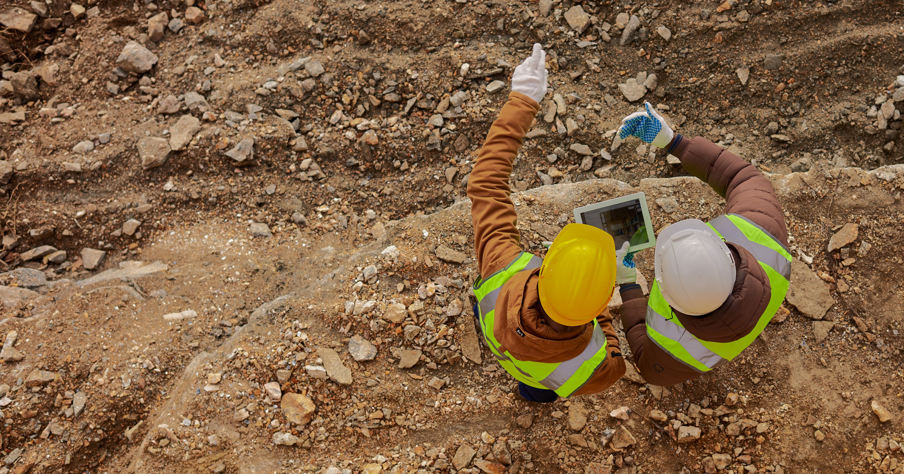
Imagine being able to virtually walk through your site anytime, anywhere. With SpatialSense, construction managers can visualize real-time site conditions through digital twins, track progress, and detect deviations long before they turn into costly problems.
The platform integrates multi-sensor data including LiDAR, imagery, and IoT feeds to provide a complete, up-to-date view of the project environment. From excavation to finishing, every phase of construction is captured, analyzed, and visualized.
Whether you’re checking progress from the office or reviewing site updates remotely, SpatialSense ensures you’re always connected to what’s happening on the ground.
Intelligent Oversight for Modern Construction Management

SpatialSense transforms construction oversight from reactive problem-solving to proactive, data-driven management. Designed with the realities of construction workflows in mind, it combines AI-powered analytics, digital twin visualization, and automation tools to help teams make faster, more informed decisions.
Track construction progress automatically through 3D visualizations and analytics dashboards.
Detect issues early, from structural deviations to equipment misuse.
Compare as-built vs. as-designed models to identify discrepancies in minutes.
Generate automated reports, saving hours of manual documentation.
Mark and assign action items directly on the 3D model or site map so problems are identified and addressed faster.
Leave comments and collaborate with engineers, contractors, and site teams in real time, ensuring everyone stays aligned.
By merging AI for construction monitoring with collaborative project management tools, SpatialSense helps teams reduce rework, prevent delays, and improve coordination across all stakeholders, from on-site engineers to project owners.
Collaboration Without Boundaries

SpatialSense is built for teamwork and transparency. Its cloud-based construction management platform enables all stakeholders, from site engineers to project owners, to access and interact with project data anytime, anywhere.
Whether reviewing digital twin visuals, sharing updates, or commenting on issues directly within the platform, every team member works from a single source of truth. This unified environment ensures real-time collaboration, faster communication, and complete alignment across the entire project lifecycle.
Seamless Integration with Your Existing Workflows

Construction projects often involve multiple systems such as BIM models, scheduling tools, and safety software. SpatialSense integrates effortlessly with industry standards, ensuring a smooth flow of information without disrupting established workflows.
It enhances construction management by connecting data across teams and tools. Its cloud-based platform enables team members to access, share, and annotate site data securely from anywhere, fostering transparency and accountability at every stage.
Transforming the Way Projects Are Managed

SpatialSense isn’t just another project management tool, it’s a smart digital twin ecosystem built for modern infrastructure development. It empowers construction managers to:
Monitor site performance continuously through visual and analytical insights, reducing manual inspection hours by up to 80% ( McKinsey & Company, The impact and opportunities of automation in construction, Dec 2019)
Reduce downtime and risk by predicting potential bottlenecks and maintenance needs — achieving 30-50% fewer unplanned disruptions (Quantifying the value of predictive maintenance)
Improve coordination among teams with unified, data-backed communication that accelerates issue resolution by 40-60% (Digital Twins in the Construction Industry: A Comprehensive Review)
Ensure compliance and documentation with traceable digital records — reducing reporting and audit-preparation time by 50-70% (PwC case study: “Document Automation at Unprecedented Scale”)
How the Adoption of Digital Twin Technology and AI-Powered Analytics Transformed the HS2 Project
When construction began on HS2, the United Kingdom’s largest infrastructure project, the team faced a massive challenge: hundreds of kilometers of track, thousands of workers, and millions of data points spread across dozens of contractors. Manual inspections and fragmented reporting made it nearly impossible to stay on schedule.
To overcome this, HS2 adopted a digital twin ecosystem powered by LiDAR scanning and an AI-based analytics platform.
With continuous data capture from drones and mobile scanners, engineers could monitor site progress and safety without physically being on-site, reducing manual inspection hours by around 80%. Predictive models began analyzing sensor data to forecast potential delays and maintenance issues, helping the team cut unplanned downtime by up to 40%.
Instead of juggling emails and spreadsheets, every stakeholder from design teams to site managers worked on a shared digital model, visualizing issues and tracking them in real time. This shift halved issue resolution time and virtually eliminated miscommunication between field and office.
Because every inspection, change, and approval was automatically documented within the twin, compliance reporting became almost effortless. What once took weeks now took days, a 60% reduction in reporting time.
The success of HS2 demonstrates how digital twin technology and AI-powered analytics can redefine infrastructure management. The world’s growing cities and transport networks must embrace this innovation to optimize operations, streamline workflows, and build smarter, safer, and more resilient infrastructure for the future.
Build Smarter and Manage Better with SpatialSense
In an industry where time and accuracy define success, SpatialSense equips construction managers with the clarity, control, and collaboration they need to deliver results.
By combining spatial intelligence, automation, and AI-driven analytics, SpatialSense turns complex construction workflows into manageable, measurable, and predictable operations.
For construction managers aiming to stay ahead of schedule, under budget, and in full control, SpatialSense isn’t just a tool, it’s the platform you can’t build without.
Ready to take control of every site, every update, and every decision?
Discover SpatialSense, the smarter way to manage your construction projects.
In construction, every decision counts, yet most teams still rely on disconnected tools, manual inspections, fragmented reports, and outdated data to run complex projects. The result? Missed deadlines, rework, and limited visibility across the project lifecycle.
SpatialSense changes that.
Developed by Kodifly, SpatialSense is an AI-powered construction management and monitoring platform that combines digital twin technology, data analytics, and automation to transform how infrastructure projects are managed. It delivers a single source of truth for every construction site, helping teams visualize real-time conditions, track progress, and make faster decisions.
A Single Source of Truth for Every Construction Site
Imagine being able to virtually walk through your site anytime, anywhere. With SpatialSense, construction managers can visualize real-time site conditions through digital twins, track progress, and detect deviations long before they turn into costly problems.
The platform integrates multi-sensor data including LiDAR, imagery, and IoT feeds to provide a complete, up-to-date view of the project environment. From excavation to finishing, every phase of construction is captured, analyzed, and visualized.
Whether you’re checking progress from the office or reviewing site updates remotely, SpatialSense ensures you’re always connected to what’s happening on the ground.
Intelligent Oversight for Modern Construction Management
SpatialSense transforms construction oversight from reactive problem-solving to proactive, data-driven management. Designed with the realities of construction workflows in mind, it combines AI-powered analytics, digital twin visualization, and automation tools to help teams make faster, more informed decisions.
Track construction progress automatically through 3D visualizations and analytics dashboards.
Detect issues early, from structural deviations to equipment misuse.
Compare as-built vs. as-designed models to identify discrepancies in minutes.
Generate automated reports, saving hours of manual documentation.
Mark and assign action items directly on the 3D model or site map so problems are identified and addressed faster.
Leave comments and collaborate with engineers, contractors, and site teams in real time, ensuring everyone stays aligned.
By merging AI for construction monitoring with collaborative project management tools, SpatialSense helps teams reduce rework, prevent delays, and improve coordination across all stakeholders, from on-site engineers to project owners.
Collaboration Without Boundaries
SpatialSense is built for teamwork and transparency. Its cloud-based construction management platform enables all stakeholders, from site engineers to project owners, to access and interact with project data anytime, anywhere.
Whether reviewing digital twin visuals, sharing updates, or commenting on issues directly within the platform, every team member works from a single source of truth. This unified environment ensures real-time collaboration, faster communication, and complete alignment across the entire project lifecycle.
Seamless Integration with Your Existing Workflows
Construction projects often involve multiple systems such as BIM models, scheduling tools, and safety software. SpatialSense integrates effortlessly with industry standards, ensuring a smooth flow of information without disrupting established workflows.
It enhances construction management by connecting data across teams and tools. Its cloud-based platform enables team members to access, share, and annotate site data securely from anywhere, fostering transparency and accountability at every stage.
Transforming the Way Projects Are Managed
SpatialSense isn’t just another project management tool, it’s a smart digital twin ecosystem built for modern infrastructure development. It empowers construction managers to:
Monitor site performance continuously through visual and analytical insights, reducing manual inspection hours by up to 80% ( McKinsey & Company, The impact and opportunities of automation in construction, Dec 2019)
Reduce downtime and risk by predicting potential bottlenecks and maintenance needs — achieving 30-50% fewer unplanned disruptions (Quantifying the value of predictive maintenance)
Improve coordination among teams with unified, data-backed communication that accelerates issue resolution by 40-60% (Digital Twins in the Construction Industry: A Comprehensive Review)
Ensure compliance and documentation with traceable digital records — reducing reporting and audit-preparation time by 50-70% (PwC case study: “Document Automation at Unprecedented Scale”)
How the Adoption of Digital Twin Technology and AI-Powered Analytics Transformed the HS2 Project
When construction began on HS2, the United Kingdom’s largest infrastructure project, the team faced a massive challenge: hundreds of kilometers of track, thousands of workers, and millions of data points spread across dozens of contractors. Manual inspections and fragmented reporting made it nearly impossible to stay on schedule.
To overcome this, HS2 adopted a digital twin ecosystem powered by LiDAR scanning and an AI-based analytics platform.
With continuous data capture from drones and mobile scanners, engineers could monitor site progress and safety without physically being on-site, reducing manual inspection hours by around 80%. Predictive models began analyzing sensor data to forecast potential delays and maintenance issues, helping the team cut unplanned downtime by up to 40%.
Instead of juggling emails and spreadsheets, every stakeholder from design teams to site managers worked on a shared digital model, visualizing issues and tracking them in real time. This shift halved issue resolution time and virtually eliminated miscommunication between field and office.
Because every inspection, change, and approval was automatically documented within the twin, compliance reporting became almost effortless. What once took weeks now took days, a 60% reduction in reporting time.
The success of HS2 demonstrates how digital twin technology and AI-powered analytics can redefine infrastructure management. The world’s growing cities and transport networks must embrace this innovation to optimize operations, streamline workflows, and build smarter, safer, and more resilient infrastructure for the future.
Build Smarter and Manage Better with SpatialSense
In an industry where time and accuracy define success, SpatialSense equips construction managers with the clarity, control, and collaboration they need to deliver results.
By combining spatial intelligence, automation, and AI-driven analytics, SpatialSense turns complex construction workflows into manageable, measurable, and predictable operations.
For construction managers aiming to stay ahead of schedule, under budget, and in full control, SpatialSense isn’t just a tool, it’s the platform you can’t build without.
Ready to take control of every site, every update, and every decision?
Discover SpatialSense, the smarter way to manage your construction projects.
Table of Content
Oct 17, 2025
Interested to find out how Kodifly transforms the infrastructure space?

Revolutionizing Site Supervision Powered by SpatialSense’s Site Diary Feature
Mar 2, 2026

10 Construction Site Operations Powered by SpatialSense
Jan 29, 2026
Who Can Benefit from SpatialSense and How?
Dec 30, 2025

Smarter O&M with Temperature Data & Digital Twins
Nov 28, 2025