Inside Aramco’s Projects: Powering Progress with Digital Intelligence
Inside Aramco’s Projects: Powering Progress with Digital Intelligence

Every day, Saudi Aramco operates on a scale few organizations in the world can rival — producing over 12.8 million barrels of oil equivalent per day and investing nearly US $50 billion annually in capital projects. From vast oil fields and cross-country pipeline networks to sprawling refineries, road systems, and even a new 46,000-seat stadium for the 2034 World Cup, Aramco’s infrastructure footprint spans land, sea, and city. It’s a living ecosystem of engineering, logistics, and innovation — operating with precision, safety, and sustainability at its core.
So the question becomes:
How does a company operating at this scale ensure every decision, across thousands of assets and active projects, is informed, fast, and precise?
Aramco’s Infrastructure Scale: Operations, Oil Fields, Pipelines, and Other Projects
Aramco’s vast infrastructure spans exploration fields, pipelines, refineries, and major construction projects that power Saudi Arabia’s energy network and economic growth.
Exploration
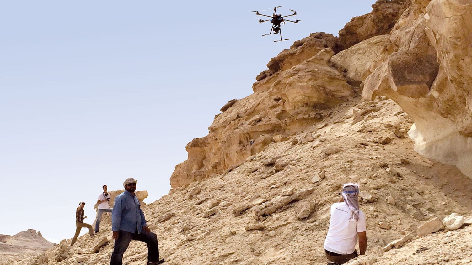
Photo Credit - Aramco
At the core of Aramco’s operations is exploration, a field that demands advanced geoscience and spatial technologies to locate new hydrocarbon reserves across Saudi Arabia’s vast onshore and offshore regions. This process requires sophisticated tools such as seismic imaging, AI-driven analysis, and 3D geological modeling to achieve the precision and efficiency needed for sustainable energy production and continued innovation in subsurface mapping.
Pipeline Networks
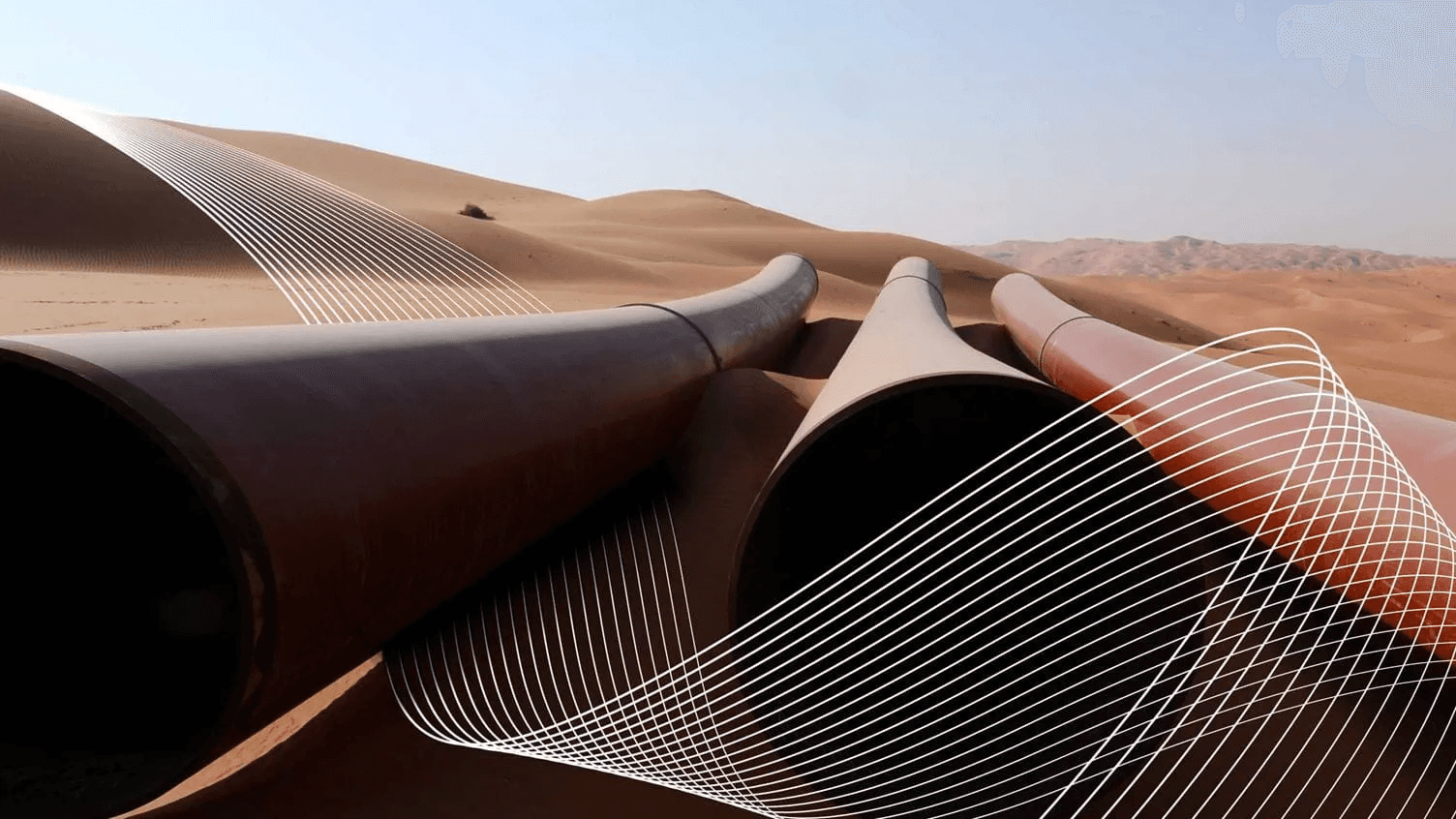
Photo Credit - Aramco
Aramco operates one of the world’s largest energy transport systems, including the 1,200-kilometer East–West Crude Oil Pipeline and the 3,850-kilometer Master Gas System. Managing these extensive networks demands precise spatial intelligence for planning, monitoring, and predictive maintenance, ensuring reliable energy flow across the Kingdom.
Road Infrastructure
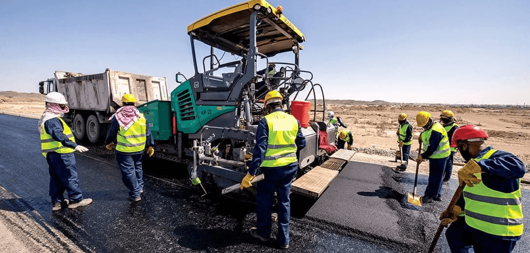
Photo Credit - Aramco
Supporting its industrial and residential operations, Aramco manages one of Saudi Arabia’s largest private road networks. These internal routes link refineries, gas plants, terminals, and worker communities, enabling smooth logistics and operational connectivity across remote and urban zones.
World Cup 2034 Saudi Arabia
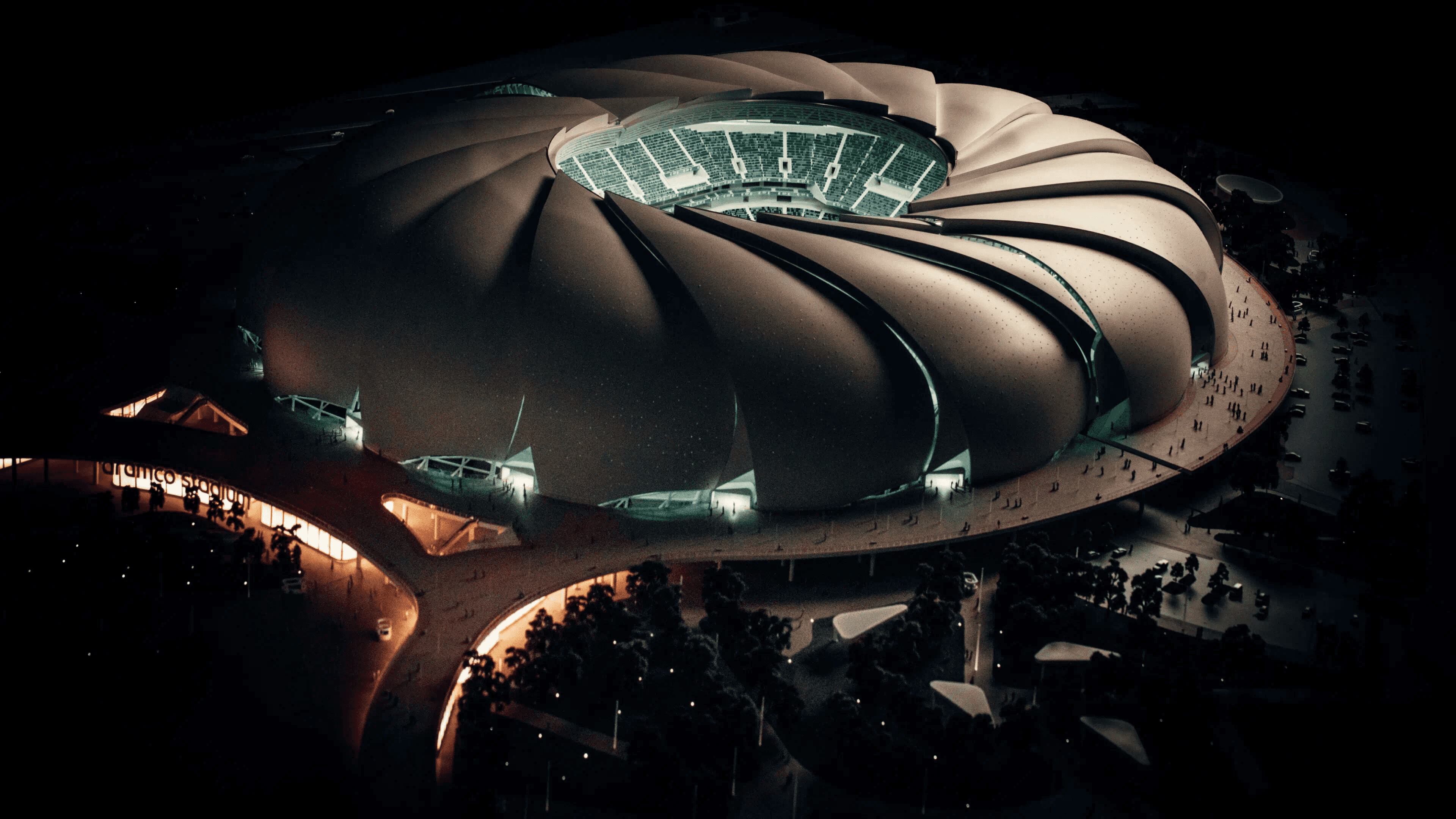
Photo Credit - Aramco
Among Aramco’s most ambitious construction projects is the Aramco Stadium in Al Khobar, a 46,000-seat venue designed by Populous and built by BESIX–Al Bawani. The project combines advanced engineering, energy-efficient systems, and architectural design inspired by the Arabian Gulf, positioning it as a landmark ahead of the 2027 AFC Asian Cup and 2034 FIFA World Cup.
Aramco’s Mega Projects
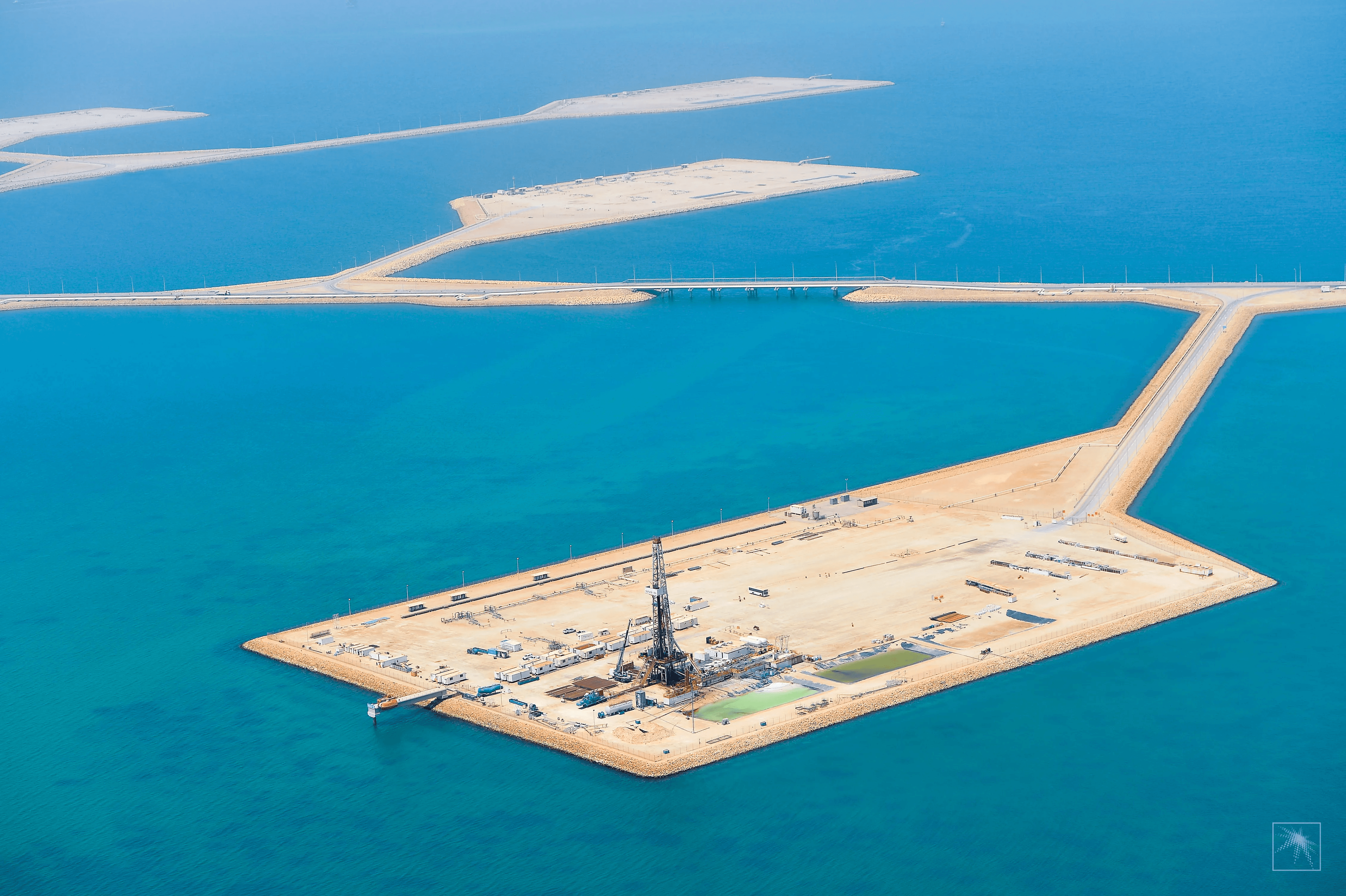
Photo Credit - Aramco
From the Manifa Offshore Oil Field and Sadara Petrochemicals Complex to the Fadhili and Wasit Gas Plants, Aramco’s mega projects highlight its engineering and operational scale. These developments, spanning oil islands, industrial complexes, and gas facilities, reflect Aramco’s ability to deliver world-class infrastructure with precision, efficiency, and innovation.
The Unique Challenges
Operating at this magnitude introduces complex management challenges, from real-time visibility and safety oversight to data fragmentation across departments. What makes the project management of these operations & projects at Aramco different isn't just the scale it's the sensitivity, stakes, and simultaneity of hundreds of projects running in parallel across extreme environments.
Traditional project monitoring tools, manual reporting, spreadsheets, siloed systems cannot keep pace with:
On-site visibility gaps: With projects spanning thousands of square kilometers, from deep desert to shallow offshore waters, maintaining continuous oversight is nearly impossible using conventional methods.
Real-time progress tracking: Weekly or monthly manual inspections create blind spots. By the time an issue is reported, it may have cascaded into costly delays.
Safety management: Aramco recorded over 80 million hours without injury on the Manifa project alone. Maintaining this standard across all operations requires proactive hazard detection, not reactive incident response.
Cross-department coordination: When pipelines, refineries, marine operations, and construction projects intersect, data fragmentation across departments becomes a bottleneck for decision-making.
Data fragmentation: With contractors using different systems, planners working off outdated drawings, and field teams relying on manual measurements, the "single source of truth" often doesn't exist.
Aramco implemented the Capital Management System (CMS) for projects like Fadhili, enabling the project team to increase efficient capital use and deliver at a lower comparative cost than industry peers. With these challenges in mind, the next question becomes:
how can data-driven intelligence transform how Aramco monitors progress in real time?
How Kodifly Can Help Aramco Lead the Next Infrastructure Revolution
Enter Kodifly, a new-generation innovator transforming how infrastructure is captured, analyzed, and managed through AI and digital intelligence.
Kodifly's ecosystem follows three critical stages:
1. Data Capture: Eyes Everywhere
Kodifly deploys a range of hardware systems tailored to different project needs:
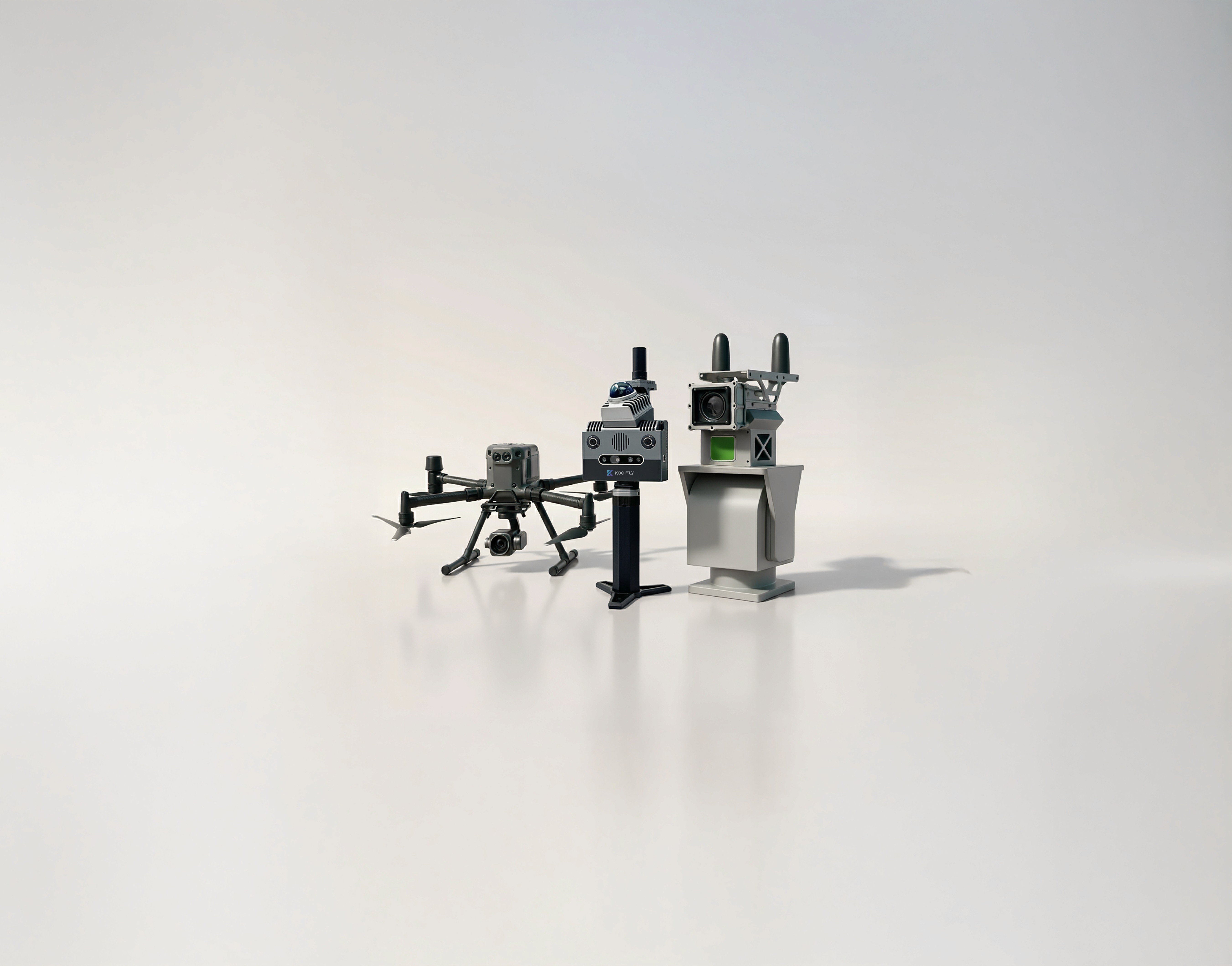
Drones for Aerial Mapping
Unmanned Aerial Vehicles (UAVs) equipped with LiDAR sensors and high-resolution cameras capture large-scale construction sites, offshore platforms, and pipeline corridors from above. Drones excel at:
Topographic surveys of vast desert and coastal terrains before, during, and after construction
Progress monitoring across multiple simultaneous projects, comparing real-time site conditions against BIM models
Hard-to-access zones such as offshore structures, bridges, and hazardous environments where ground teams cannot easily reach
For Aramco's operations, spanning thousands of kilometers across challenging geographies — aerial mapping provides comprehensive, repeatable coverage that manual surveys simply cannot achieve.
Fixed-Point Systems for Continuous Monitoring
Mounted on poles or permanent structures, fixed-point LiDAR and camera sensors provide 24/7 autonomous monitoring of critical construction zones. These systems are ideal for:
High-risk areas such as excavations, crane zones, and offshore platform construction
Deviation detection, automatically flagging changes in alignment, slope, or structure that deviate from design specifications
Port monitoring and management, where sensors continuously observe vessel berthing, cargo operations, and quay-side activity, improving situational awareness, operational efficiency, and safety in busy maritime environments
Safety monitoring, tracking hazardous conditions like unauthorized entry into danger zones or structural movement
By operating continuously without human intervention, fixed-point systems act as a "digital watchdog," ensuring no changes or risks go unnoticed between scheduled inspections.
Handheld Scanners for Flexibility and Precision
Portable handheld LiDAR scanners give engineers and inspectors the agility to capture close-range details that drones or fixed sensors might miss. They excel at:
Indoor environments such as control rooms, processing facilities, and administrative buildings
Pipeline networks in hard-to-access places, providing quick, accurate scans without shutting down operations
Complex features like reinforcement bars, façade elements, and MEP (mechanical, electrical, plumbing) systems
Handheld scanners offer unmatched portability and speed.
Mobile Mapping Systems for On-the-Go Scanning
Kodifly's SS 360 Mobile Mapping System can be mounted on any vehicle to scan infrastructure while driving at normal traffic speeds. Equipped with high-precision LiDAR and six synchronized cameras, the SS-360 captures:
Potholes and cracks on roads and highways
Lane markings and road surface deterioration
Signboards, detecting issues like tilt deviations and damage
For Aramco, which owns and maintains extensive internal road networks within its residential compounds, refineries, terminals, and industrial zones, such a mobile mapping offers a powerful solution for large-scale, real-time assessment. These systems enable continuous scanning of internal routes and access roads without disrupting daily operations, helping engineers quickly identify issues. By integrating this data into digital twins, Aramco can prioritize maintenance, optimize resurfacing schedules, and ensure its internal transport infrastructure remains safe, efficient, and resilient.
2. Digital Twin Creation: A Realistic Digital Representation of an Environment’s Ground Reality

Once data is captured, Kodifly processes it into 3D, spatially accurate digital twins — interactive digital replicas of Aramco's assets and projects.
Unlike static blueprints or photos, a digital twin is a living 3D model that updates as conditions change. Stakeholders can:
Virtually walk through construction sites without being physically present
Measure dimensions with millimeter-level accuracy
Inspect progress and identify deviations in real time
Compare current conditions against design intent (BIM models) and historical scans
For mega projects like Manifa, Sadara, or Fadhili — where thousands of contractors, hundreds of subcontractors, and dozens of engineering disciplines must coordinate, a centralized digital twin becomes the single source of truth.
3. AI-Powered Insights: From Data to Decisions
Raw point clouds and 3D models are powerful, but Spatial Sense - Kodifly's AI-powered infrastructure management platform takes them further by transforming data into actionable intelligence visualized on an intuitive dashboard.
Core Features of Spatial Sense:
Real-Time Project Monitoring
Spatial Sense continuously updates project status based on the latest scans, providing instant visibility into what's happening across all sites. Decision-makers can track multiple projects simultaneously without physical site visits.
Asset Tracking
Every piece of equipment, every material stockpile, and every structural component is tracked in the digital environment. This enables precise inventory management and prevents costly delays due to missing or misplaced assets.
Issue Tracking
Spatial Sense automatically detects and flags issues such as:
Structural deviations from design specifications
Safety hazards like unprotected edges or unauthorized access
Quality defects in concrete, welding, or surface finishes
Issues are logged, assigned, and tracked until resolution, ensuring nothing falls through the cracks.
Automated Processing
AI algorithms process scan data automatically, eliminating the manual labor of reviewing thousands of images or point clouds. This reduces project monitoring workload by up to 80%.
BIM Integration
Spatial Sense integrates seamlessly with Building Information Modeling (BIM) systems, enabling automated progress tracking, clash detection, and quality verification workflows. Teams can compare as-built conditions against design models to identify discrepancies early.
Deviation Analysis
The platform performs automated "as-built vs. as-designed" comparisons, highlighting areas where construction deviates from plans. This early detection prevents issues from cascading into expensive rework.
Safety and Compliance
Spatial Sense monitors compliance with safety protocols and regulatory requirements, providing automated alerts when violations are detected. For Aramco — where safety records like 80 million injury-free hours are the standard — this proactive approach is invaluable.
The Result: Smarter, Safer, Faster Project Delivery
By implementing Kodifly’s hardware and Spatial Sense platform, Aramco can achieve:
Real-Time Progress and Issue Tracking
Weekly or monthly progress reports become obsolete. With continuous monitoring, Aramco's project managers gain instant visibility into:
Which tasks are complete, in progress, or delayed
Where bottlenecks are forming
Which areas need immediate attention
This level of transparency enables proactive management rather than reactive firefighting.
The Result
Quantifiable benefits include:
50% reduction in project cycles through early deviation detection
60% cut in rework costs by catching errors before they escalate
80% reduction in manual monitoring workload through automation
35% faster inspections using automated LiDAR and AI analysis
For Aramco's $52-58 billion annual capital expenditure, even small percentage improvements translate to hundreds of millions of dollars saved.
Every day, Saudi Aramco operates on a scale few organizations in the world can rival — producing over 12.8 million barrels of oil equivalent per day and investing nearly US $50 billion annually in capital projects. From vast oil fields and cross-country pipeline networks to sprawling refineries, road systems, and even a new 46,000-seat stadium for the 2034 World Cup, Aramco’s infrastructure footprint spans land, sea, and city. It’s a living ecosystem of engineering, logistics, and innovation — operating with precision, safety, and sustainability at its core.
So the question becomes:
How does a company operating at this scale ensure every decision, across thousands of assets and active projects, is informed, fast, and precise?
Aramco’s Infrastructure Scale: Operations, Oil Fields, Pipelines, and Other Projects
Aramco’s vast infrastructure spans exploration fields, pipelines, refineries, and major construction projects that power Saudi Arabia’s energy network and economic growth.
Exploration
Photo Credit - Aramco
At the core of Aramco’s operations is exploration, a field that demands advanced geoscience and spatial technologies to locate new hydrocarbon reserves across Saudi Arabia’s vast onshore and offshore regions. This process requires sophisticated tools such as seismic imaging, AI-driven analysis, and 3D geological modeling to achieve the precision and efficiency needed for sustainable energy production and continued innovation in subsurface mapping.
Pipeline Networks
Photo Credit - Aramco
Aramco operates one of the world’s largest energy transport systems, including the 1,200-kilometer East–West Crude Oil Pipeline and the 3,850-kilometer Master Gas System. Managing these extensive networks demands precise spatial intelligence for planning, monitoring, and predictive maintenance, ensuring reliable energy flow across the Kingdom.
Road Infrastructure
Photo Credit - Aramco
Supporting its industrial and residential operations, Aramco manages one of Saudi Arabia’s largest private road networks. These internal routes link refineries, gas plants, terminals, and worker communities, enabling smooth logistics and operational connectivity across remote and urban zones.
World Cup 2034 Saudi Arabia
Photo Credit - Aramco
Among Aramco’s most ambitious construction projects is the Aramco Stadium in Al Khobar, a 46,000-seat venue designed by Populous and built by BESIX–Al Bawani. The project combines advanced engineering, energy-efficient systems, and architectural design inspired by the Arabian Gulf, positioning it as a landmark ahead of the 2027 AFC Asian Cup and 2034 FIFA World Cup.
Aramco’s Mega Projects
Photo Credit - Aramco
From the Manifa Offshore Oil Field and Sadara Petrochemicals Complex to the Fadhili and Wasit Gas Plants, Aramco’s mega projects highlight its engineering and operational scale. These developments, spanning oil islands, industrial complexes, and gas facilities, reflect Aramco’s ability to deliver world-class infrastructure with precision, efficiency, and innovation.
The Unique Challenges
Operating at this magnitude introduces complex management challenges, from real-time visibility and safety oversight to data fragmentation across departments. What makes the project management of these operations & projects at Aramco different isn't just the scale it's the sensitivity, stakes, and simultaneity of hundreds of projects running in parallel across extreme environments.
Traditional project monitoring tools, manual reporting, spreadsheets, siloed systems cannot keep pace with:
On-site visibility gaps: With projects spanning thousands of square kilometers, from deep desert to shallow offshore waters, maintaining continuous oversight is nearly impossible using conventional methods.
Real-time progress tracking: Weekly or monthly manual inspections create blind spots. By the time an issue is reported, it may have cascaded into costly delays.
Safety management: Aramco recorded over 80 million hours without injury on the Manifa project alone. Maintaining this standard across all operations requires proactive hazard detection, not reactive incident response.
Cross-department coordination: When pipelines, refineries, marine operations, and construction projects intersect, data fragmentation across departments becomes a bottleneck for decision-making.
Data fragmentation: With contractors using different systems, planners working off outdated drawings, and field teams relying on manual measurements, the "single source of truth" often doesn't exist.
Aramco implemented the Capital Management System (CMS) for projects like Fadhili, enabling the project team to increase efficient capital use and deliver at a lower comparative cost than industry peers. With these challenges in mind, the next question becomes:
how can data-driven intelligence transform how Aramco monitors progress in real time?
How Kodifly Can Help Aramco Lead the Next Infrastructure Revolution
Enter Kodifly, a new-generation innovator transforming how infrastructure is captured, analyzed, and managed through AI and digital intelligence.
Kodifly's ecosystem follows three critical stages:
1. Data Capture: Eyes Everywhere
Kodifly deploys a range of hardware systems tailored to different project needs:
Drones for Aerial Mapping
Unmanned Aerial Vehicles (UAVs) equipped with LiDAR sensors and high-resolution cameras capture large-scale construction sites, offshore platforms, and pipeline corridors from above. Drones excel at:
Topographic surveys of vast desert and coastal terrains before, during, and after construction
Progress monitoring across multiple simultaneous projects, comparing real-time site conditions against BIM models
Hard-to-access zones such as offshore structures, bridges, and hazardous environments where ground teams cannot easily reach
For Aramco's operations, spanning thousands of kilometers across challenging geographies — aerial mapping provides comprehensive, repeatable coverage that manual surveys simply cannot achieve.
Fixed-Point Systems for Continuous Monitoring
Mounted on poles or permanent structures, fixed-point LiDAR and camera sensors provide 24/7 autonomous monitoring of critical construction zones. These systems are ideal for:
High-risk areas such as excavations, crane zones, and offshore platform construction
Deviation detection, automatically flagging changes in alignment, slope, or structure that deviate from design specifications
Port monitoring and management, where sensors continuously observe vessel berthing, cargo operations, and quay-side activity, improving situational awareness, operational efficiency, and safety in busy maritime environments
Safety monitoring, tracking hazardous conditions like unauthorized entry into danger zones or structural movement
By operating continuously without human intervention, fixed-point systems act as a "digital watchdog," ensuring no changes or risks go unnoticed between scheduled inspections.
Handheld Scanners for Flexibility and Precision
Portable handheld LiDAR scanners give engineers and inspectors the agility to capture close-range details that drones or fixed sensors might miss. They excel at:
Indoor environments such as control rooms, processing facilities, and administrative buildings
Pipeline networks in hard-to-access places, providing quick, accurate scans without shutting down operations
Complex features like reinforcement bars, façade elements, and MEP (mechanical, electrical, plumbing) systems
Handheld scanners offer unmatched portability and speed.
Mobile Mapping Systems for On-the-Go Scanning
Kodifly's SS 360 Mobile Mapping System can be mounted on any vehicle to scan infrastructure while driving at normal traffic speeds. Equipped with high-precision LiDAR and six synchronized cameras, the SS-360 captures:
Potholes and cracks on roads and highways
Lane markings and road surface deterioration
Signboards, detecting issues like tilt deviations and damage
For Aramco, which owns and maintains extensive internal road networks within its residential compounds, refineries, terminals, and industrial zones, such a mobile mapping offers a powerful solution for large-scale, real-time assessment. These systems enable continuous scanning of internal routes and access roads without disrupting daily operations, helping engineers quickly identify issues. By integrating this data into digital twins, Aramco can prioritize maintenance, optimize resurfacing schedules, and ensure its internal transport infrastructure remains safe, efficient, and resilient.
2. Digital Twin Creation: A Realistic Digital Representation of an Environment’s Ground Reality
Once data is captured, Kodifly processes it into 3D, spatially accurate digital twins — interactive digital replicas of Aramco's assets and projects.
Unlike static blueprints or photos, a digital twin is a living 3D model that updates as conditions change. Stakeholders can:
Virtually walk through construction sites without being physically present
Measure dimensions with millimeter-level accuracy
Inspect progress and identify deviations in real time
Compare current conditions against design intent (BIM models) and historical scans
For mega projects like Manifa, Sadara, or Fadhili — where thousands of contractors, hundreds of subcontractors, and dozens of engineering disciplines must coordinate, a centralized digital twin becomes the single source of truth.
3. AI-Powered Insights: From Data to Decisions
Raw point clouds and 3D models are powerful, but Spatial Sense - Kodifly's AI-powered infrastructure management platform takes them further by transforming data into actionable intelligence visualized on an intuitive dashboard.
Core Features of Spatial Sense:
Real-Time Project Monitoring
Spatial Sense continuously updates project status based on the latest scans, providing instant visibility into what's happening across all sites. Decision-makers can track multiple projects simultaneously without physical site visits.
Asset Tracking
Every piece of equipment, every material stockpile, and every structural component is tracked in the digital environment. This enables precise inventory management and prevents costly delays due to missing or misplaced assets.
Issue Tracking
Spatial Sense automatically detects and flags issues such as:
Structural deviations from design specifications
Safety hazards like unprotected edges or unauthorized access
Quality defects in concrete, welding, or surface finishes
Issues are logged, assigned, and tracked until resolution, ensuring nothing falls through the cracks.
Automated Processing
AI algorithms process scan data automatically, eliminating the manual labor of reviewing thousands of images or point clouds. This reduces project monitoring workload by up to 80%.
BIM Integration
Spatial Sense integrates seamlessly with Building Information Modeling (BIM) systems, enabling automated progress tracking, clash detection, and quality verification workflows. Teams can compare as-built conditions against design models to identify discrepancies early.
Deviation Analysis
The platform performs automated "as-built vs. as-designed" comparisons, highlighting areas where construction deviates from plans. This early detection prevents issues from cascading into expensive rework.
Safety and Compliance
Spatial Sense monitors compliance with safety protocols and regulatory requirements, providing automated alerts when violations are detected. For Aramco — where safety records like 80 million injury-free hours are the standard — this proactive approach is invaluable.
The Result: Smarter, Safer, Faster Project Delivery
By implementing Kodifly’s hardware and Spatial Sense platform, Aramco can achieve:
Real-Time Progress and Issue Tracking
Weekly or monthly progress reports become obsolete. With continuous monitoring, Aramco's project managers gain instant visibility into:
Which tasks are complete, in progress, or delayed
Where bottlenecks are forming
Which areas need immediate attention
This level of transparency enables proactive management rather than reactive firefighting.
The Result
Quantifiable benefits include:
50% reduction in project cycles through early deviation detection
60% cut in rework costs by catching errors before they escalate
80% reduction in manual monitoring workload through automation
35% faster inspections using automated LiDAR and AI analysis
For Aramco's $52-58 billion annual capital expenditure, even small percentage improvements translate to hundreds of millions of dollars saved.
Table of Content
Nov 6, 2025
Interested to find out how Kodifly transforms the infrastructure space?

Revolutionizing Site Supervision Powered by SpatialSense’s Site Diary Feature
Mar 2, 2026

10 Construction Site Operations Powered by SpatialSense
Jan 29, 2026
Who Can Benefit from SpatialSense and How?
Dec 30, 2025

Smarter O&M with Temperature Data & Digital Twins
Nov 28, 2025