Spatial Sense Scanner
Spatial Sense Scanner
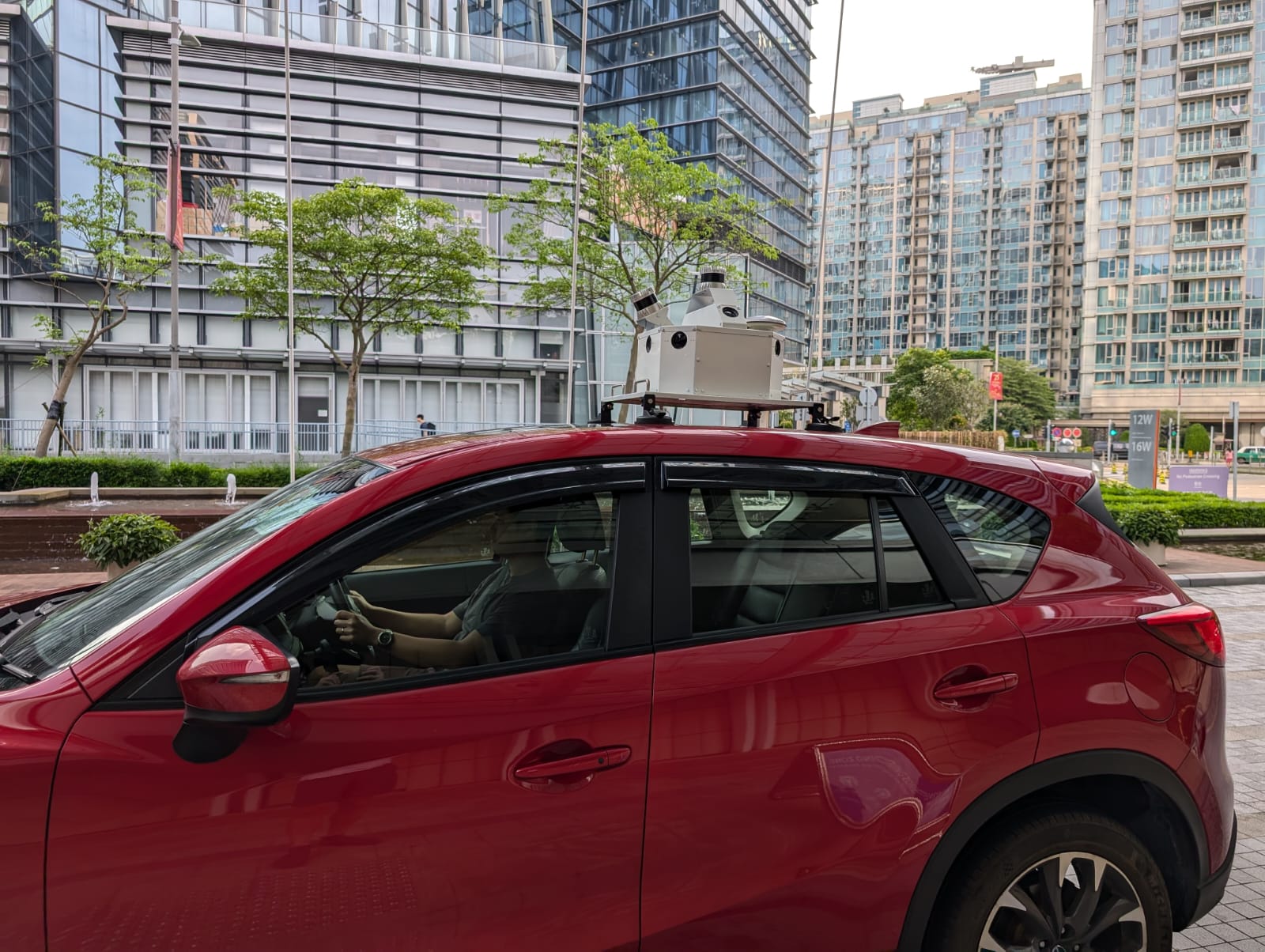
Mountable anywhere—from poles to vehicles
Spatial Sense Scanner provides real-time insights.
Mountable anywhere—from poles to vehicles
Spatial Sense Scanner provides real-time insights.

Spatial Sense Scanner
Spatial Sense Scanner
Mountable anywhere—from poles to vehicles
Spatial Sense Scanner provides real-time insights.
Mountable anywhere—from poles to vehicles
Spatial Sense Scanner provides real-time insights.
SpatialSense Scanner (SS-128) is a scanner combining machine vision cameras, LiDAR sensor, and IMU that has the ability to scan the environment and create a colourized map in real time. The collected map can be visualized on the web-based platform and/or used for further processing to detect irregularities and individual objects.
SpatialSense Scanner (SS-128) is a scanner combining machine vision cameras, LiDAR sensor, and IMU that has the ability to scan the environment and create a colourized map in real time. The collected map can be visualized on the web-based platform and/or used for further processing to detect irregularities and individual objects.
SpatialSense Scanner (SS-128) is a scanner combining machine vision cameras, LiDAR sensor, and IMU that has the ability to scan the environment and create a colourized map in real time. The collected map can be visualized on the web-based platform and/or used for further processing to detect irregularities and individual objects.
Product Highlights
Unmatched Precision in Monitoring
Unmatched Precision in Monitoring
Unmatched Precision in Monitoring
The Spatial Sense Scanner employs cutting-edge LiDAR technology to generate accurate point cloud views, detecting intrusions, obstacles, and beings in real-time.
The Spatial Sense Scanner employs cutting-edge LiDAR technology to generate accurate point cloud views, detecting intrusions, obstacles, and beings in real-time.
The Spatial Sense Scanner employs cutting-edge LiDAR technology to generate accurate point cloud views, detecting intrusions, obstacles, and beings in real-time.

Digital Twin Creation
Digital Twin Creation
Digital Twin Creation
Generates precise digital twins of infrastructure settings, enabling detailed analysis and monitoring.
Generates precise digital twins of infrastructure settings, enabling detailed analysis and monitoring.
Generates precise digital twins of infrastructure settings, enabling detailed analysis and monitoring.
Real Time Data Acquisition
Real Time Data Acquisition
Real Time Data Acquisition
Offers the capability to gather data in real time, essential for dynamic environments like airports, highways, and railways.
Offers the capability to gather data in real time, essential for dynamic environments like airports, highways, and railways.
Offers the capability to gather data in real time, essential for dynamic environments like airports, highways, and railways.


Mobile & Fixed Installations
Mobile & Fixed Installations
Mobile & Fixed Installations
Versatile deployment options, suitable for both fixed installations (for continuous monitoring) and mobile setups (on patrol cars or trains for on-the-go scanning).
Versatile deployment options, suitable for both fixed installations (for continuous monitoring) and mobile setups (on patrol cars or trains for on-the-go scanning).
Versatile deployment options, suitable for both fixed installations (for continuous monitoring) and mobile setups (on patrol cars or trains for on-the-go scanning).
Applications
Versatile Applications Across Industries
Versatile Applications Across Industries
Versatile Applications Across Industries
From airports, railways, highways to construction sites, see how our product is making a difference.
From airports, railways, highways to construction sites, see how our product is making a difference.
From airports, railways, highways to construction sites, see how our product is making a difference.

Construction Sites
Our LiDAR camera technology facilitates high-resolution 3D mapping of construction sites, ensuring precise monitoring of project progress, site conditions, and safety compliance.

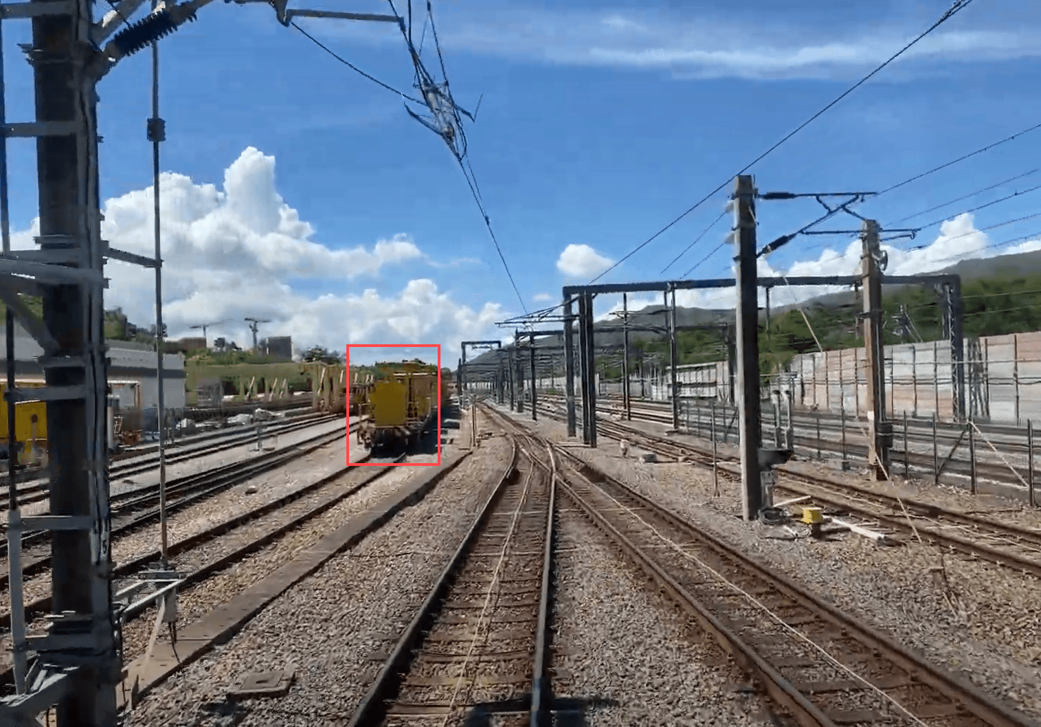
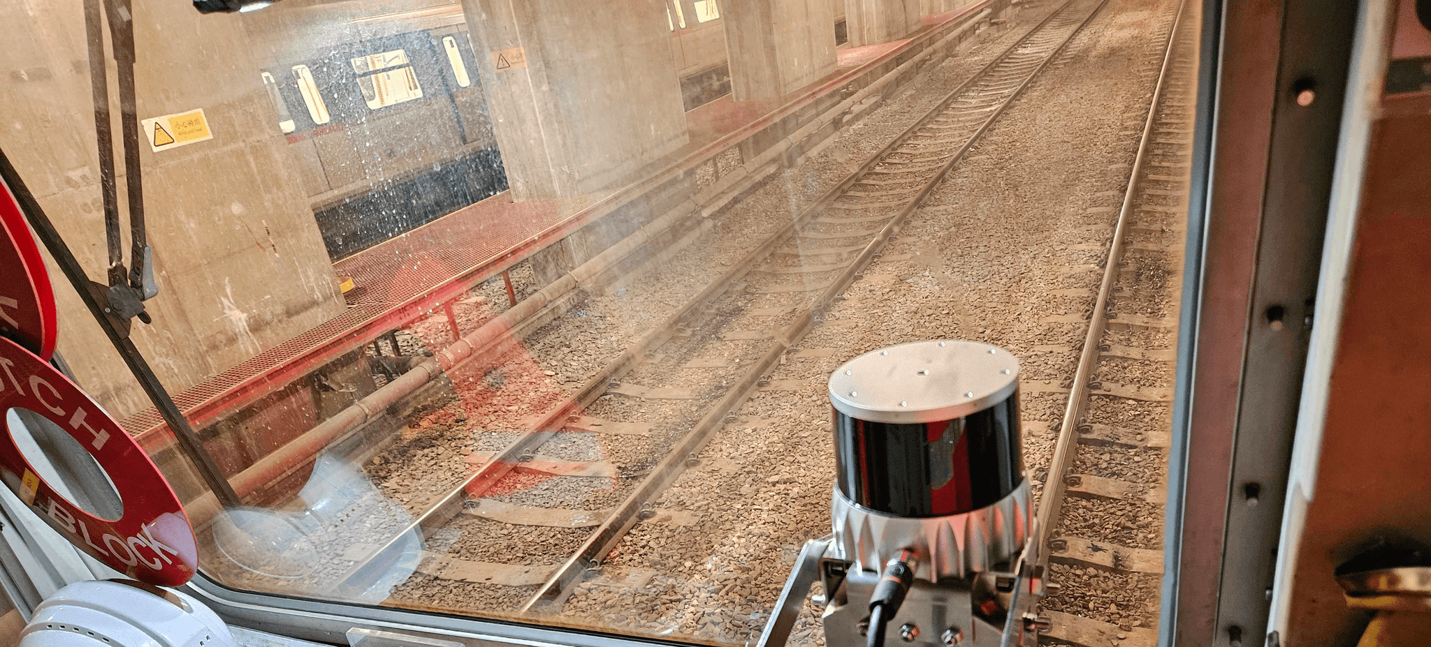
Railways
Our LiDAR camera technology offers high-resolution 3D mapping of railway infrastructure, enabling precise monitoring of track conditions and surrounding environments

Highways
Our LiDAR camera technology delivers high-resolution 3D mapping of highway infrastructures, allowing for precise monitoring of traffic conditions, road integrity, and surrounding areas.

Airports
Our LiDAR camera technology provides high-resolution 3D mapping of airport facilities, enabling detailed monitoring of runways, taxiways, and terminal surroundings.
Railways
Our LiDAR camera technology offers high-resolution 3D mapping of railway infrastructure, enabling precise monitoring of track conditions and surrounding environments
Airports
Our LiDAR camera technology provides high-resolution 3D mapping of airport facilities, enabling detailed monitoring of runways, taxiways.
Railways
Our LiDAR camera technology offers high-resolution 3D mapping of railway infrastructure, enabling precise monitoring of track conditions and surrounding environments
Highways
Our LiDAR camera technology delivers high-resolution 3D mapping of highway infrastructures, allowing for precise monitoring of traffic conditions, road integrity, and surrounding areas.
Highways
Our LiDAR camera technology offers high-resolution 3D mapping of railway infrastructure, enabling precise monitoring of track conditions and surrounding environments
Construction Sites
Our LiDAR camera technology provides high-resolution 3D mapping of airport facilities, enabling detailed monitoring of runways, taxiways, and terminal surroundings.
Airports
Our LiDAR camera technology provides high-resolution 3D mapping of airport facilities, enabling detailed monitoring of runways, taxiways, and terminal surroundings.
Construction Sites
Our LiDAR camera technology facilitates high-resolution 3D mapping of construction sites, ensuring precise monitoring of project progress, site conditions, and safety compliance.
Use Cases
Industrial Applications
Industrial Applications
Industrial Applications
Evaluating the effect of our solutions in the field of industry
Evaluating the effect of our solutions in the field of industry
Mobile Mapping System
With SS360 MMS, you can capture high-resolution data without disrupting traffic. Our system uses LiDAR and IoT for precise mapping of highways and railways, providing critical insights for infrastructure management.

Tree Guard : Vegetation Management System
TreeGuard automatically scans for vegetation encroachment into the rail corridor. It provides detailed 3D models of the rail corridor for accurate analysis.
Track Vision : Train Perception System
The system’s advanced automatic obstacle detection continuously scans the tracks for potential hazards, alerting drivers in real time. This proactive feature minimizes collision risks, enhancing safety and ensuring smoother operations.
Ballast Vue : Ballast Profile Monitoring
BallastVue combines advanced LiDAR and camera fusion to generate real-time 3D models of track ballast. This technology ensures optimal distribution and stability, enhancing overall track performance.
Mobile Mapping System
With SS360 MMS, you can capture high-resolution data without disrupting traffic. Our system uses LiDAR and IoT for precise mapping of highways and railways, providing critical insights for infrastructure management.
Tree Guard :
Vegetation Management SystemTreeGuard automatically scans for vegetation encroachment into the rail corridor. It provides detailed 3D models of the rail corridor for accurate analysis.
Track Vision :
Train Perception SystemThe system’s advanced automatic obstacle detection continuously scans the tracks for potential hazards, alerting drivers in real time. This proactive feature minimizes collision risks, enhancing safety and ensuring smoother operations.
Ballast Vue :
Ballast Profile MonitoringBallastVue combines advanced LiDAR and camera fusion to generate real-time 3D models of track ballast. This technology ensures optimal distribution and stability, enhancing overall track performance.
Tech Specs
SS-128 Spatial Sense Scanner
SS-128 Spatial Sense Scanner
SS-128 Spatial Sense Scanner
Combines advanced LiDAR sensors with high-resolution cameras to scan and capture real-time, 3D images of infrastructure environments.
Combines advanced LiDAR sensors with high-resolution cameras to scan and capture real-time, 3D images of infrastructure environments.
Combines advanced LiDAR sensors with high-resolution cameras to scan and capture real-time, 3D images of infrastructure environments.
Camera
Sensor
3 high-resolution machine vision cameras
Resolution
Up to 5MP(Mega Pixel)
Frame Rate
15 - 20 fps
Field of View
100
x
40
Power
12V DC, <8W
LiDAR
Resolution
32 - 128 Channels
Range
200 - 350 m
Field of View
360
x
45
Accuracy
2 cm
Sensor
Components
Gyroscope
Accelerometer
Compass
Power Efficiency
Optimized for low power consumption
Motion Tracking
Accurate tracking of orientation and movement
GNSS with RTK
Multi-Constellation Support
GPS
GLONASS
Galileo
Tilt Compensation
Up to 15
Rugged Design
IP67-rated for durability in harsh conditions
Real-Time Kinematics (RTK)
Enhanced positioning accuracy
Software
Specifications
Functionality
Supports SLAM (Simultaneous Localization and Mapping)
Localization
Accurate mapping in GNSS-denied environments
Tilt Compensation
Up to 15
Technologies Used
LiDAR for detailed spatial data
IMU for motion tracking and orientation
Applications
Ideal for indoor mapping, autonomous navigation, and robotics
Camera
Camera
Sensor
Sensor
3 high-resolution machine vision cameras
3 high-resolution machine vision cameras
Resolution
Resolution
Up to 10MP(Mega Pixel)
Up to 10MP(Mega Pixel)
Frame Rate
Frame Rate
15 - 20 fps
15 - 20 fps
Field of View
Field of View
100
100
x
x
40
40
Power
Power
12V DC, <8W
12V DC, <8W
LiDAR
LiDAR
Resolution
Resolution
32 - 128 Channels
32 - 128 Channels
Range
Range
200 - 350 m
200 - 350 m
Field of View
Field of View
360
x
45
Accuracy
Accuracy
2 cm
2 cm
Sensor
Sensor
Components
Components
Gyroscope
Accelerometer
Compass
Gyroscope
Accelerometer
Compass
Power Efficiency
Power Efficiency
Optimized for low power consumption
Optimized for low power consumption
Motion Tracking
Motion Tracking
Accurate tracking of orientation and movement
Accurate tracking of orientation and movement
GNSS with RTK
GNSS with RTK
Multi-Constellation Support
Multi-Constellation Support
GPS
GLONASS
Galileo
GPS
GLONASS
Galileo
Tilt Compensation
Tilt Compensation
Up to 15
Up to 15
Rugged Design
Rugged Design
IP67-rated for durability in harsh conditions
IP67-rated for durability in harsh conditions
Real-Time Kinematics (RTK)
Real-Time Kinematics (RTK)
Enhanced positioning accuracy
Enhanced positioning accuracy
Software Specifications
Software
Functionality
Functionality
Supports SLAM (Simultaneous Localization and Mapping)
Supports SLAM (Simultaneous Localization and Mapping)
Localization
Localization
Accurate mapping in GNSS-denied environments
Accurate mapping in GNSS-denied environments
Tilt Compensation
Tilt Compensation
Up to 15
Up to 15
Technologies Used
Technologies Used
LiDAR for detailed spatial data
IMU for motion tracking and orientation
LiDAR for detailed spatial data
IMU for motion tracking and orientation
Applications
Applications
Ideal for indoor mapping, autonomous navigation, and robotics
Ideal for indoor mapping, autonomous navigation, and robotics
Product Information Hub
Product Information Hub
Product Information Hub
Frequently Asked Questions
Frequently Asked Questions
Frequently Asked Questions
What is the technology behind SpatialSense?
Is a specific processing device required for the scanner?
How robust is the SpatialSense hardware?
Are there any specific installation requirements for SpatialSense?
What data can I get from SpatialSense?
Schedule a Meeting With Our Sales Team
Find out how SpatialSense can help transform your business.