
SpatialScanner
SpatialScanner
SpatialScanner
Precision in the Palm of your Hand
Precision in the Palm of
your Hand
Precision in the Palm of your Hand

Portable, Precise, and Powerful 3D Scanning
Portable, Precise, and Powerful 3D Scanning
The GeoScan S1 is a compact and powerful 3D laser scanner built for modern construction and infrastructure projects. It’s lightweight, portable, and rugged, giving you fast and accurate site capture right at your fingertips.
The GeoScan S1 is a compact and powerful 3D laser scanner built for modern construction and infrastructure projects. It’s lightweight, portable, and rugged, giving you fast and accurate site capture right at your fingertips.
Integrated lightweight body
Integrated lightweight body

Integrated lightweight body
Integrated lightweight body

One touch start instant scan
One touch start instant scan

Integrated lightweight body
Integrated lightweight body

Overview
Product Features
Product Features

Multi Sensor
Fusion
Multi Sensor
Fusion
Multi Sensor
Fusion

Microsecond Synchronization
Microsecond Synchronization
Microsecond Synchronization

High-Precision Scanning
High-Precision
Scanning
High-Precision
Scanning

Large-Scene
Coverage
Large-Scene
Coverage
Large-Scene
Coverage

Multi-Scenario
Adaptability
Multi-Scenario
Adaptability
Multi-Scenario
Adaptability
Lightweight
& Portable
Lightweight & Portable
Lightweight & Portable

Real-Time Mapping Preview
Real-Time Mapping Preview
Real-Time Mapping Preview

Multi-Format
Export
Multi-Format
Export
Multi-Format
Export

Support unmanned platforms
Support unmanned platforms
Support unmanned platforms

SDK Support
SDK Support
SDK Support
Proven Impact. Real Results
Real-time Modeling with
High-fidelity Reconstruction
Real-time Modeling with High-fidelity Reconstruction
With integrated sensing technology and real-time mapping, GeoScan S1 delivers accurate 3D data instantly. With its built-in HD color camera, the system produces detailed, true-to-life 3D visuals, giving users a clear and comprehensive view of their environment.
Points Per Second Point Cloud Generation
Points Per Second Point Cloud Generation
Points Per Second Point Cloud Generation
Angular Coverage
Angular Coverage
Angular Coverage
Maximum Measurement Range
Maximum Measurement Range
Maximum Measurement Range
Maximum Measurement Range
Accuracy
Accuracy
With integrated sensing technology and real-time mapping, GeoScan S1 delivers accurate 3D data instantly. With its built-in HD color camera, the system produces detailed, true-to-life 3D visuals, giving users a clear and comprehensive view of their environment.
With integrated sensing technology and real-time mapping, GeoScan S1 delivers accurate 3D data instantly. With its built-in HD color camera, the system produces detailed, true-to-life 3D visuals, giving users a clear and comprehensive view of their environment.
Multi-Sensor Fusion Technology
Multi-Sensor Fusion Technology
Multi-Sensor Fusion Technology
Powered by LiDAR, high-definition cameras, IMU, and RTK technology, the system combines multi-sensor SLAM and microsecond-level synchronization to deliver fast, accurate 3D mapping in any indoor or outdoor environment.
With multi-sensor fusion, microsecond synchronization, and real-time SLAM, the system delivers high-accuracy, colorized point cloud data through its integrated HD camera and LiDAR,
With multi-sensor fusion, microsecond synchronization, abd real-time SLAM, the system delivers high-accuracy, colorized point cloud data through its integrated HD camera and LiDAR,

See it in action
See it in action
See it in action
Scan. Upload. Analyze.
Scan. Upload. Analyze.


Scan
Capture the environment quickly with GeoScan S1.
Scan
Capture the environment quickly with GeoScan S1.
Application Usecases
See how our tech captures, processes, and transforms the real world live and on the ground.
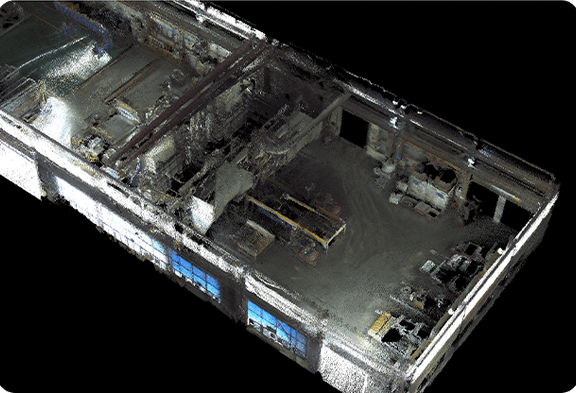
Construction Progress Monitoring
Construction Progress Monitoring
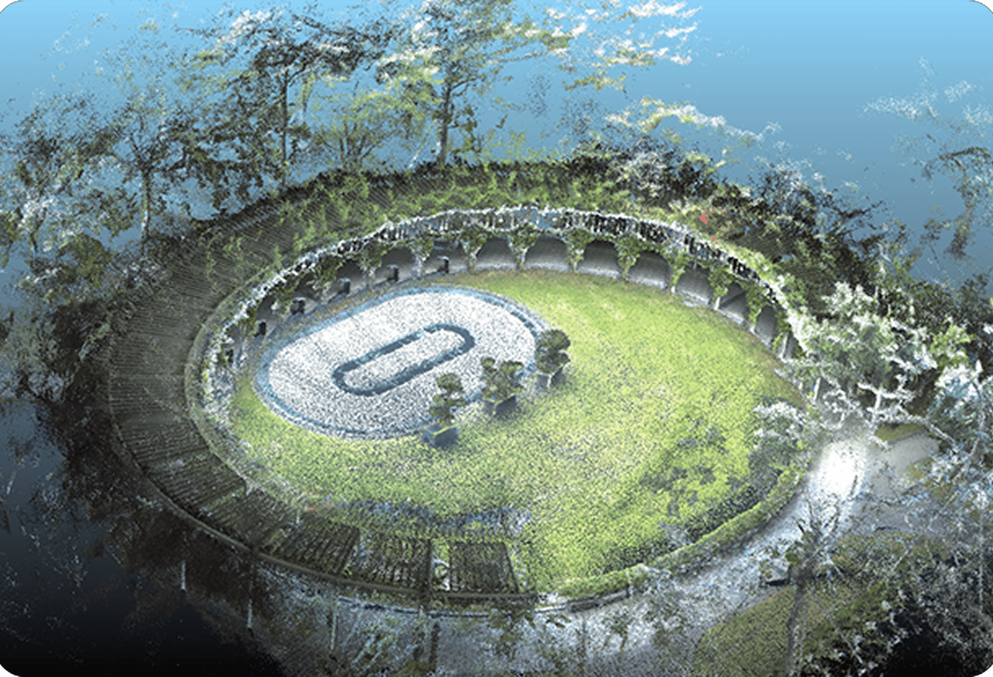
Quick Site Surveys
Road Infrastructure Mapping
Quick Site Surveys
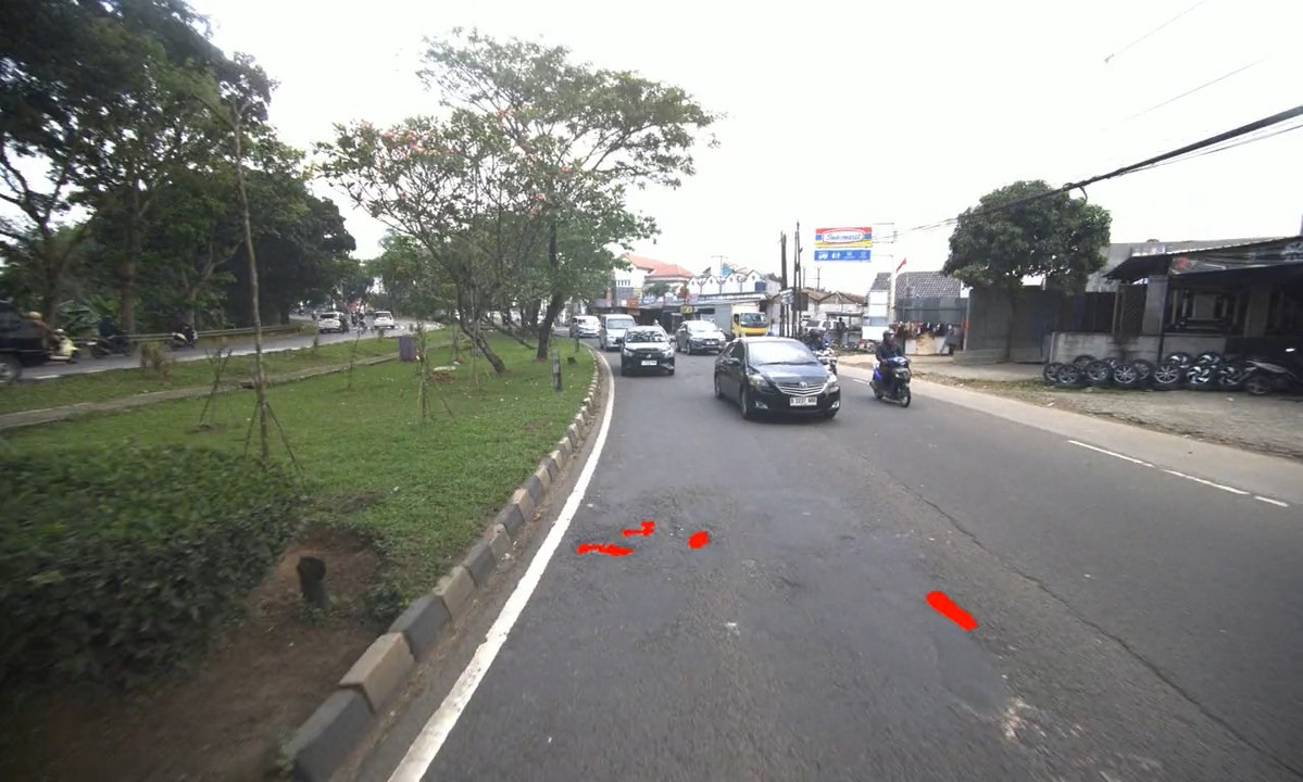
Road Condition Survey
Road Condition Survey
