
Deploy once with minimal maintenance, and scale seamlessly from single-site monitoring to multi-site operations—all with consistent, reliable performance.


Transform your construction with
Transform your construction with
Transform your construction with
SpatialSense 4D Reality Capture is a complete solution built for smart construction. It combines fixed-point, aerial, and handheld LiDAR systems to deliver accurate 3D data from every angle of your site. From continuous monitoring and rapid drone mapping to detailed indoor scans, SS 4DRC ensures full visibility across the construction lifecycle, helping teams track progress, spot deviations early, and make informed decisions with confidence.
SpatialSense 4D Reality Capture is a complete solution built for smart construction. It combines fixed-point, aerial, and handheld LiDAR systems to deliver accurate 3D data from every angle of your site. From continuous monitoring and rapid drone mapping to detailed indoor scans, SS 4DRC ensures full visibility across the construction lifecycle, helping teams track progress, spot deviations early, and make informed decisions with confidence.
SpatialSense 4D Reality Capture is a complete solution built for smart construction. It combines fixed-point, aerial, and handheld LiDAR systems to deliver accurate 3D data from every angle of your site. From continuous monitoring and rapid drone mapping to detailed indoor scans, SS 4DRC ensures full visibility across the construction lifecycle, helping teams track progress, spot deviations early, and make informed decisions with confidence.
Key capabilities that power accurate, real-time construction monitoring and streamlined site management
Key capabilities that power accurate, real-time construction monitoring and streamlined site management
Key capabilities that power accurate, real-time construction monitoring and streamlined site management
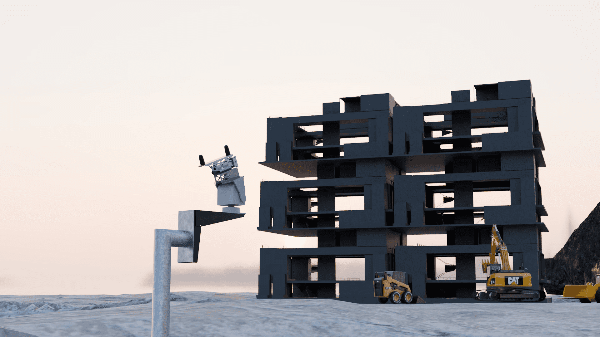
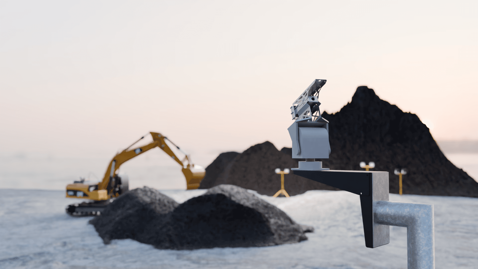
Fixed
Fixed
Drone
Drone
Handheld
Handheld

Accuracy ± 2cm
Accuracy ± 2cm
Accuracy ± 2cm

Scanning Range up to 190m
Scanning Range up to 190m
Scanning Range up to 190m
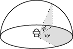
FOV Horizontal 70°, Vertical 72°
FOV Horizontal 70°, Vertical 72°
FOV Horizontal 70°, Vertical 72°

240,000 pts/sec
240,000 pts/sec
240,000 pts/sec

Real-time Point Cloud Visualisation
Real-time Point Cloud Visualisation
Real-time Point Cloud Visualisation

IPv 65 Rated
IPv 65 Rated
IPv 65 Rated
Deploy. Capture. Analyze.
Deploy. Capture. Analyze.
Deploy. Capture. Analyze.


Scan
Capture the environment quickly with GeoScan S1.
Scan
Capture the environment quickly with GeoScan S1.
Scan
Capture the environment quickly with GeoScan S1.
See how our tech captures, processes, and transforms the real world live and on the ground.
See how our tech captures, processes, and transforms the real world live and on the ground.
See how our tech captures, processes, and transforms the real world live and on the ground.

Fixed-point LiDAR enables continuous site monitoring, handheld SLAM LiDAR captures detailed indoor environments, and drone-mounted LiDAR surveys and maps large-scale outdoor construction areas with speed and precision.

SpatialSense is engineered for rapid installation. It requires minimal setup and begins operating immediately, reducing on-site integration time and labor requirements.

The system is built to operate in demanding construction conditions, including dust, vibration, rainfall, and extreme temperatures — ensuring uninterrupted performance across project phases.

Once deployed, SpatialSense continuously captures site data without manual intervention. It enables comprehensive project visibility, even beyond standard working hours.

Equipped with onboard processing, SpatialSense delivers faster results with reduced bandwidth dependency. Insights are generated locally, allowing real-time responsiveness in the field.
Fixed-point LiDAR enables continuous site monitoring, handheld SLAM LiDAR captures detailed indoor environments, and drone-mounted LiDAR surveys and maps large-scale outdoor construction areas with speed and precision.
SpatialSense is engineered for rapid installation. It requires minimal setup and begins operating immediately, reducing on-site integration time and labor requirements.
The system is built to operate in demanding construction conditions, including dust, vibration, rainfall, and extreme temperatures — ensuring uninterrupted performance across project phases.
Once deployed, SpatialSense continuously captures site data without manual intervention. It enables comprehensive project visibility, even beyond standard working hours.
Equipped with onboard processing, SpatialSense delivers faster results with reduced bandwidth dependency. Insights are generated locally, allowing real-time responsiveness in the field.
Rugged. Reliable. Ready for the field.
Deploy once with minimal maintenance, and scale seamlessly from single-site monitoring to multi-site operations—all with consistent, reliable performance.
LIDAR
240,000 pts/sec, 190m range, ±2cm accuracy
Camera
10MP global shutter, HDR support
IMU/GNSS
RTK enabled, 6-axis IMU
Power
24V DC input, UPS backup (1hr)
Enclosure
IP65-rated, stainless steel
Installation
Pole or wall mount ready
Supports multi-platform compatibility, enabling effortless synchronization with your existing workflows. Capture, visualize, and analyze—all in one ecosystem.

Lightweight and quick to deploy, this handheld device captures real-time 3D data, deal for indoor, underground, or GPS-denied spaces. Versatile enough for a wide range of construction applications.
LIDAR
200,000 pts/sec, ±3 cm relative accuracy (±5 cm absolute), Livox Mid-360
Camera
Intel D435i Depth + Dual Industrial Cameras, Global Shutter, 180° FOV, 1280×1024 @201fps
IMU/GNSS
T-RTK UM982 Mobile, Full-frequency antenna, Multi-axis IMU with calibration
Weight
1.3 kg (no battery), 1.9 kg (with battery)
Battery
88.8 Wh magazine battery, 3–4 h runtime, 13.8–24V input
Storage
256 GB (expandable via TF card)
Supports multi-platform compatibility, enabling effortless synchronization with your existing workflows. Capture, visualize, and analyze—all in one ecosystem.

Capture high-precision 3D data in a single flight. Quick to deploy and simple to operate, the LiDAR drone scales smoothly from site-level tasks to infrastructure projects.
LIDAR
240,000 pts/sec, 450m range, ±2cm accuracy
Camera
20 MP RGB camera
IMU/GNSS
High‑accuracy IMU, vision sensor, GNSS fusion
Battery
5800mAh, 40 minutes (hover) / 30–35 min real-world mapping
Maximum Returns Supported
3
IP Rating
IP54-rated
Supports multi-platform compatibility, enabling effortless synchronization with your existing workflows. Capture, visualize, and analyze—all in one ecosystem.
Key capabilities that power accurate, real-time construction monitoring and streamlined site management
Key capabilities that power accurate, real-time construction monitoring and streamlined site management
Uploading...
Your file is almost finished
Seamlessly monitor MiC workflows—from off-site fabrication to on-site assembly—with 4D clarity.
Notification
Liability
07
07
Personal
14
14
Health
21
21
Track excavation progress with precision to ensure compliance and timely project delivery.
Labels
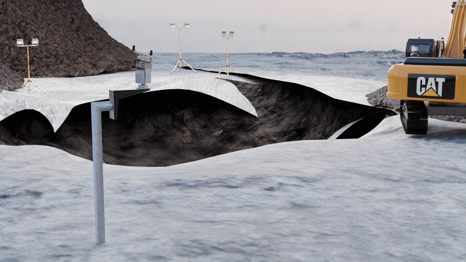
Visualize terrain changes and formation stages in real time to stay ahead of site development risks.
Notification
Liability
07
07
Personal
14
14
Health
21
21

With Thermal Camera integration, enable smarter operations and greater level of insight.
Ask everything you need to know about our products and services.
Ask everything you need to know about our products and services.
Ask everything you need to know about our products and services.
Is SpatialSense compatible with existing BIM/CAD software?
Yes! Export data to Revit, AutoCAD, and other platforms via standard formats (e.g., .LAS, .E57).
How difficult is installation?
How secure is the data?
What’s the maintenance schedule?
Can I add IoT sensors later?
Is SpatialSense compatible with existing BIM/CAD software?
Yes! Export data to Revit, AutoCAD, and other platforms via standard formats (e.g., .LAS, .E57).
How difficult is installation?
How secure is the data?
What’s the maintenance schedule?
Can I add IoT sensors later?
Is SpatialSense compatible with existing BIM/CAD software?
Yes! Export data to Revit, AutoCAD, and other platforms via standard formats (e.g., .LAS, .E57).
How difficult is installation?
How secure is the data?
What’s the maintenance schedule?
Can I add IoT sensors later?

Key capabilities that power accurate, real-time construction monitoring and streamlined site management
Uploading...
Your file is almost finished
Seamlessly monitor MiC workflows—from off-site fabrication to on-site assembly—with 4D clarity.
Notification
Liability
07
07
Personal
14
14
Health
21
21
Track excavation progress with precision to ensure compliance and timely project delivery.
Labels
Visualize terrain changes and formation stages in real time to stay ahead of site development risks.
Notification
Liability
07
07
Personal
14
14
Health
21
21
With Thermal Camera integration, enable smarter operations and greater level of insight.
Rugged. Reliable. Ready for the field.
Deploy once with minimal maintenance, and scale seamlessly from single-site monitoring to multi-site operations—all with consistent, reliable performance.
LIDAR
240,000 pts/sec, 190m range, ±2cm accuracy
Camera
10MP global shutter, HDR support
IMU/GNSS
RTK enabled, 6-axis IMU
Power
24V DC input, UPS backup (1hr)
Enclosure
IP65-rated, stainless steel
Installation
Pole or wall mount ready
Seamlessly integrates with your workflows - capture, visualize, and analyze within one unified platform
Lightweight and quick to deploy, this handheld device captures real-time 3D data, deal for indoor, underground, or GPS-denied spaces. Versatile enough for a wide range of construction applications.
LIDAR
200,000 pts/sec, ±3 cm relative accuracy (±5 cm absolute), Livox Mid-360
Camera
Intel D435i Depth + Dual Industrial Cameras, Global Shutter, 180° FOV, 1280×1024 @201fps
IMU/GNSS
T-RTK UM982 Mobile, Full-frequency antenna, Multi-axis IMU with calibration
Weight
1.3 kg (no battery), 1.9 kg (with battery)
Battery
88.8 Wh magazine battery, 3–4 h runtime, 13.8–24V input
Storage
256 GB (expandable via TF card)
Seamlessly integrates with your workflows - capture, visualize, and analyze within one unified platform
Capture high-precision 3D data in a single flight. Quick to deploy and simple to operate, the LiDAR drone scales smoothly from site-level tasks to large infrastructure projects.
LIDAR
240,000 pts/sec, 450m range, ±2cm accuracy
Camera
20 MP RGB camera
IMU/GNSS
High‑accuracy IMU, vision sensor, GNSS fusion
Battery
5800mAh, 40 minutes (hover) / 30–35 min real-world mapping
Maximum Returns Supported
3
IP Rating
IP54-rated
Seamlessly integrates with your workflows - capture, visualize, and analyze within one unified platform
Rugged. Reliable. Ready for the field.
Deploy once with minimal maintenance, and scale seamlessly from single-site monitoring to multi-site operations—all with consistent, reliable performance.
LIDAR
240,000 pts/sec, 190m range, ±2cm accuracy
Camera
10MP global shutter, HDR support
IMU/GNSS
RTK enabled, 6-axis IMU
Power
24V DC input, UPS backup (1hr)
Enclosure
IP65-rated, stainless steel
Installation
Pole or wall mount ready
Lightweight and quick to deploy, this handheld device captures real-time 3D data, deal for indoor, underground, or GPS-denied spaces. Versatile for construction applications.
LIDAR
200,000 pts/sec, ±3 cm relative accuracy (±5 cm absolute), Livox Mid-360
Camera
Intel D435i Depth + Dual Industrial Cameras, Global Shutter, 180° FOV, 1280×1024 @201fps
IMU/GNSS
T-RTK UM982 Mobile, Full-frequency antenna, Multi-axis IMU with calibration
Weight
1.3 kg (no battery), 1.9 kg (with battery)
Battery
88.8 Wh magazine battery, 3–4 h runtime, 13.8–24V input
Storage
256 GB (expandable via TF card)
Capture high-precision 3D data in a single flight. Quick to deploy and simple to operate, the LiDAR drone scales smoothly from site-level tasks to large infrastructure projects.
LIDAR
240,000 pts/sec, 450m range, ±2cm accuracy
Camera
20 MP RGB camera
IMU/GNSS
High‑accuracy IMU, vision sensor, GNSS fusion
Battery
5800mAh, 40 minutes (hover) / 30–35 min real-world mapping
Maximum Returns Supported
3
IP Rating
IP54-rated