

Transform your urban mapping & inspections with
Transform your urban mapping & inspections with
Transform your urban mapping & inspections with
Spatial Sense
360 Mobile Mapping System
Spatial Sense
360 Mobile Mapping System
Spatial Sense
360 Mobile Mapping System
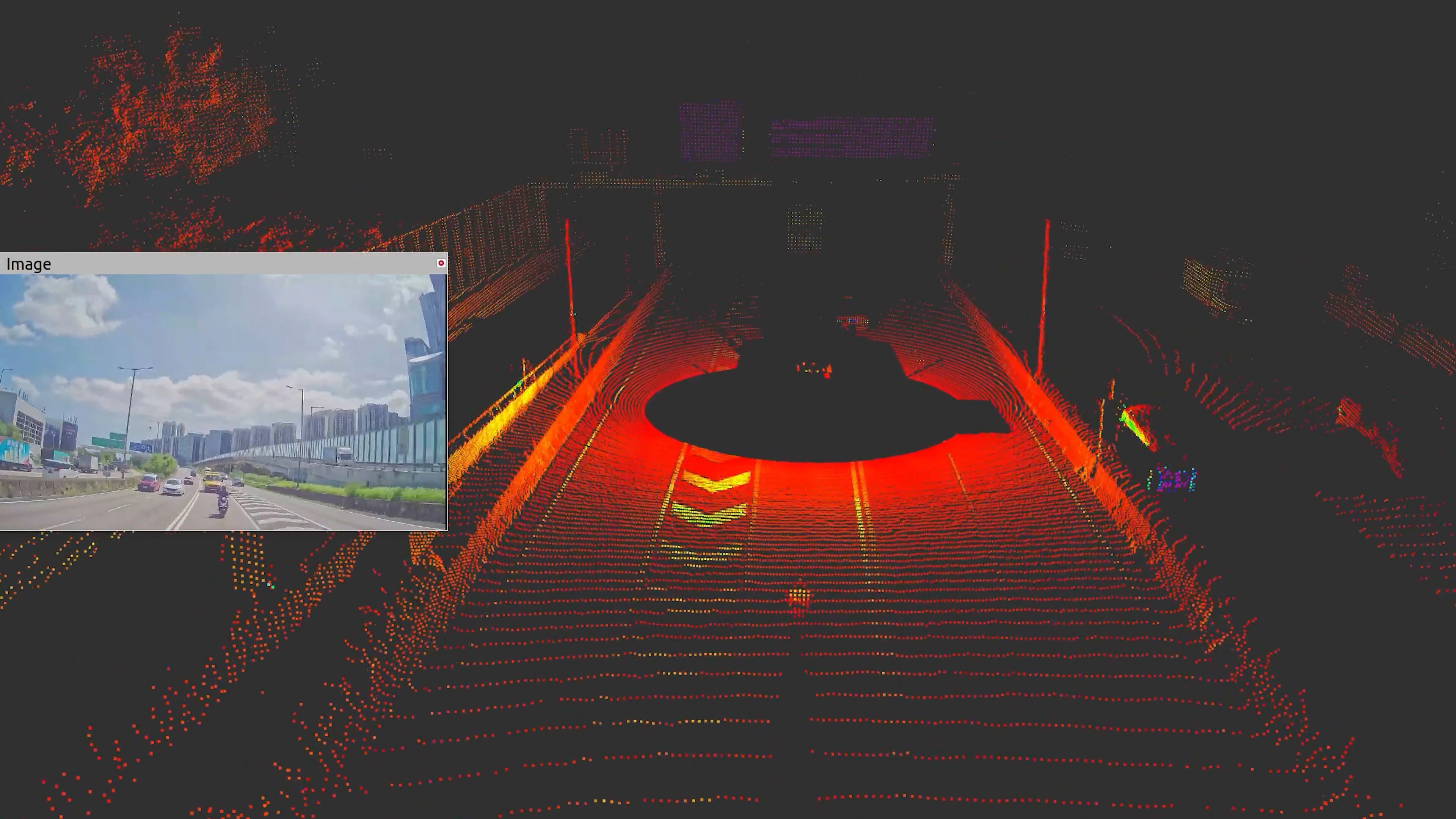
SS360 MMS is built for high-speed, high-precision mapping of urban infrastructure. Vehicle-mounted and equipped with advanced LiDAR, high-definition cameras, and GNSS/IMU positioning, it captures dense, survey-grade 3D data on the move, enabling efficient mapping, inspection, and digital twin creation for roads, highways, and city assets.
SS360 MMS is built for high-speed, high-precision mapping of urban infrastructure. Vehicle-mounted and equipped with advanced LiDAR, high-definition cameras, and GNSS/IMU positioning, it captures dense, survey-grade 3D data on the move, enabling efficient mapping, inspection, and digital twin creation for roads, highways, and city assets.
SS360 MMS is built for high-speed, high-precision mapping of urban infrastructure. Vehicle-mounted and equipped with advanced LiDAR, high-definition cameras, and GNSS/IMU positioning, it captures dense, survey-grade 3D data on the move, enabling efficient mapping, inspection, and digital twin creation for roads, highways, and city assets.
Fast. Precise. Intelligent
Fast. Precise. Intelligent
Fast. Precise. Intelligent
Streamlining Infrastructure with Real - Time Data
Streamlining Infrastructure with Real - Time Data
Streamlining Infrastructure with Real - Time Data
Overview
Overview
Overview
Features at a Glance
Features at a Glance
Features at a Glance
Key capabilities that enable large-scale, high-precision mapping for infrastructure projects, urban modeling and asset management.
Key capabilities that enable large-scale, high-precision mapping for infrastructure projects, urban modeling and asset management.
Key capabilities that enable large-scale, high-precision mapping for infrastructure projects, urban modeling and asset management.
GIS Mapping and Asset Management

GIS Mapping and Asset Management
GIS Mapping and Asset Management
Transport Infrastructure Mapping

Transport Infrastructure Mapping
Transport Infrastructure Mapping
City Modeling

City Modeling
City Modeling
Why Us
Why Us
Why Us
How does it work?
How does it work?
How does it work?
Mount.Data Collection.3D Map.
Mount.Data Collection.3D Map.
Mount.Data Collection.3D Map.


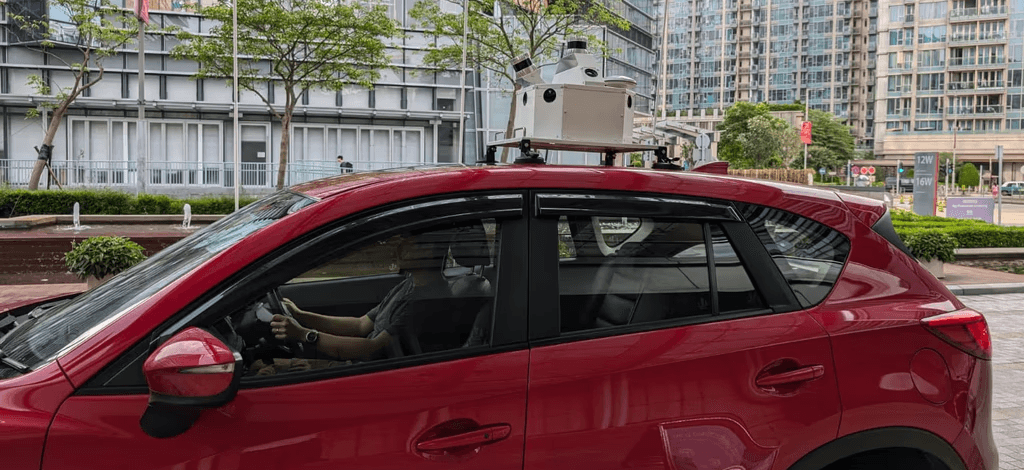
Mount
SS360 mounts on any inspection vehicle. The kit includes suction cups, data unit, control unit, and power battery.
Mount
SS360 mounts on any inspection vehicle. The kit includes suction cups, data unit, control unit, and power battery.
Mount
SS360 mounts on any inspection vehicle. The kit includes suction cups, data unit, control unit, and power battery.
Our Solutions
Our Solutions
Powering real-time mapping, obstacle detection, and infrastructure insights with LiDAR, IoT, and AI-driven systems.
Powering real-time mapping, obstacle detection, and infrastructure insights with LiDAR, IoT, and AI-driven systems.
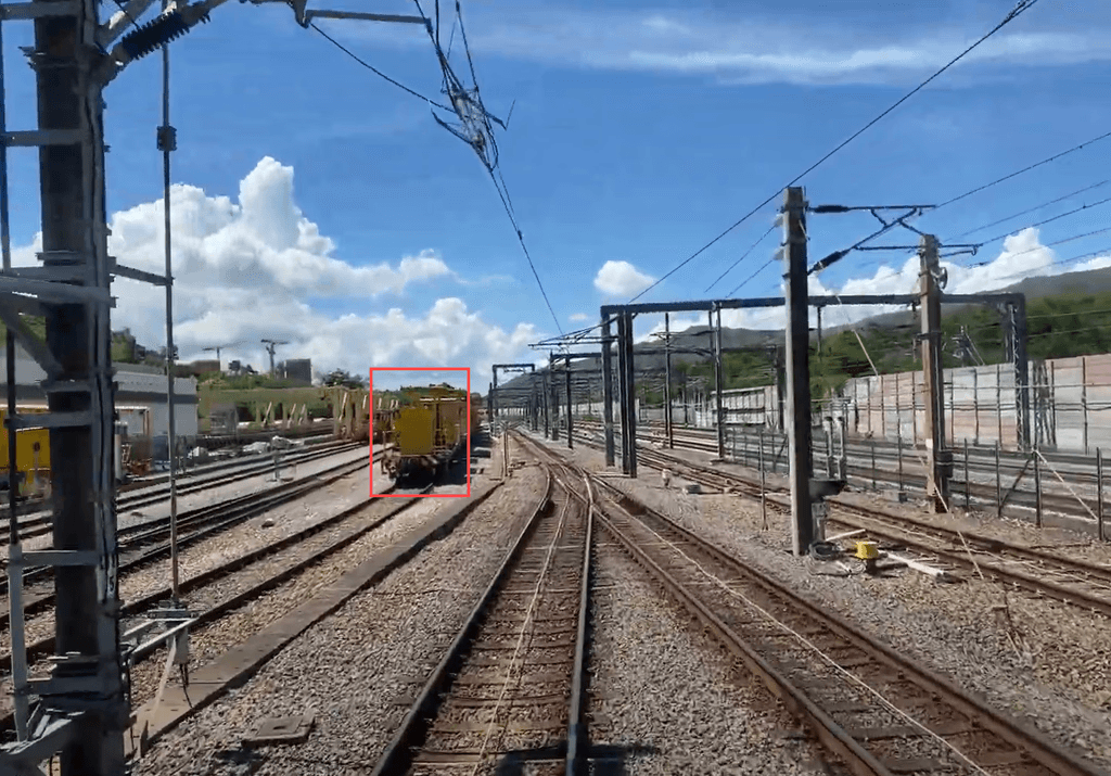
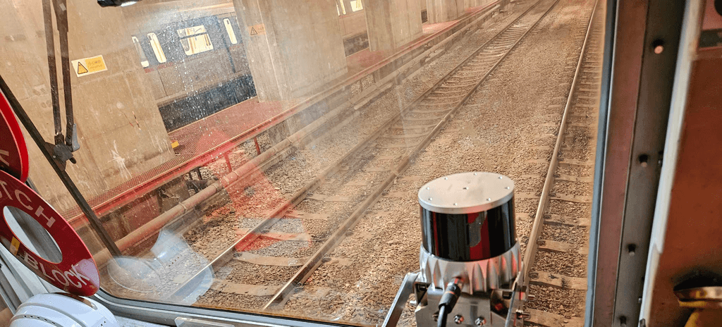
Track Vision : Train Perception System
Advanced obstacle detection scans tracks for real-time hazards. Instant alerts help drivers respond proactively. The system reduces collision risk and ensures smooth operations.
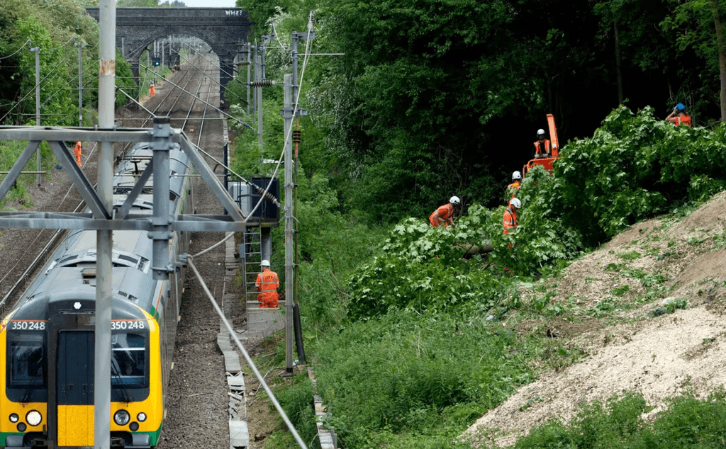
Tree Guard : Vegetation Management System
TreeGuard automatically scans for vegetation encroachment into the rail corridor. It provides detailed 3D models of the rail corridor for accurate analysis.
Mobile Mapping System for Infrastructure
SS360 MMS captures high-resolution data without interrupting traffic. LiDAR and IoT enable accurate mapping of highways and railways. It provides vital insights for smarter infrastructure.
Ballast Vue : Ballast Profile Monitoring
BallastVue fuses LiDAR and camera data for real-time 3D ballast modeling. It ensures proper distribution and stability. Enhances overall track performance.
Comparison
SS360 MMS vs. Manual Inspection
Features
Hundreds of pictures on your phone
Automated Data Collection
Non-proprietary Output Files
High Data Accuracy
Proactive Maintenance Support
Easy Report Export
Kodifly's SS360 MMS
Traditional Inspection
Frequently asked questions
Frequently asked questions
Frequently asked questions
Ask everything you need to know about our products and services.
Ask everything you need to know about our products and services.
Ask everything you need to know about our products and services.
How are these systems installed and deployed?
SS360 mounts onto any vehicle using suction cups and hardware kit, then operated via app to start scans and upload to cloud.
How secure is the data?
What’s the maintenance schedule?
Is this system compatible with my existing software workflows?
How are these systems installed and deployed?
SS360 mounts onto any vehicle using suction cups and hardware kit, then operated via app to start scans and upload to cloud.
How secure is the data?
What’s the maintenance schedule?
Is this system compatible with my existing software workflows?
How are these systems installed and deployed?
SS360 mounts onto any vehicle using suction cups and hardware kit, then operated via app to start scans and upload to cloud.
How secure is the data?
What’s the maintenance schedule?
Is this system compatible with my existing software workflows?
Ready to Build Smarter
Ready to Build Smarter
Discover how real-time data can transform your construction site.
Discover how real-time data can transform your construction site.

Our Solutions
See how our tech captures, processes, and transforms the real world live and on the ground.
Tree Guard : Vegetation Management System
TreeGuard automatically scans for vegetation encroachment into the rail corridor. It provides detailed 3D models of the rail corridor for accurate analysis.
Ballast Vue : Ballast Profile Monitoring
BallastVue fuses LiDAR and camera data for real-time 3D ballast modeling. It ensures proper distribution and stability. Enhances overall track performance.
Track Vision : Train Perception System
Advanced obstacle detection scans tracks for real-time hazards. Instant alerts help drivers respond proactively. The system reduces collision risk and ensures smooth operations.
Mobile Mapping System
SS360 MMS captures high-resolution data without interrupting traffic. LiDAR and IoT enable accurate mapping of highways and railways. It provides vital insights for smarter infrastructure.
Comparison
Comparison
SS360 MMS vs. Manual Inspection
Features
Hundreds of pictures on your phone
Automated Data Collection
Non-proprietary Output Files
High Data Accuracy
Proactive Maintenance Support
Easy Report Export
Kodifly's SS360 MMS
Traditional Inspection
Comparison
Comparison
SS360 MMS vs. Manual Inspection
Features
Hundreds of pictures on your phone
Automated Data Collection
Non-proprietary Output Files
High Data Accuracy
Proactive Maintenance Support
Easy Report Export
Kodifly's SS360 MMS
Traditional Inspection