
Spatial Sense Edge Device
SE-64
Spatial Sense Edge Device
SE-64
Spatial Sense Edge Device
SE-64
Real-time data collection and analysis for safer, smarter environments.
Real-time data collection and analysis for safer, smarter environments.
Real-time data collection and analysis for safer, smarter environments.
The SpatialSense Edge (SE-64) is a high-performance device designed for real-time data handling in the field. Featuring advanced processing capabilities and 5G connectivity, it ensures seamless operation and low-latency communication.
The SpatialSense Edge (SE-64) is a high-performance device designed for real-time data handling in the field. Featuring advanced processing capabilities and 5G connectivity, it ensures seamless operation and low-latency communication.
The SpatialSense Edge (SE-64) is a high-performance device designed for real-time data handling in the field. Featuring advanced processing capabilities and 5G connectivity, it ensures seamless operation and low-latency communication.
Product Highlights
Product Highlights
Product Highlights
Understanding the Mechanics Behind Our Technology
Understanding the Mechanics Behind Our Technology
Understanding the Mechanics Behind Our Technology
The core of SpatialSense Edge lies in its seamless integration of advanced hardware and intelligent software, transforming raw data into actionable insights. This section explores the three essential processes that drive the power and precision of our technology.
The core of SpatialSense Edge lies in its seamless integration of advanced hardware and intelligent software, transforming raw data into actionable insights. This section explores the three essential processes that drive the power and precision of our technology.
The core of SpatialSense Edge lies in its seamless integration of advanced hardware and intelligent software, transforming raw data into actionable insights. This section explores the three essential processes that drive the power and precision of our technology.
Scanning
Our state-of-the-art sensors are engineered for versatility, performing seamlessly across diverse environments, from busy airports to isolated construction sites.


Data Analysis
Once the data is captured, it undergoes rigorous analysis through our proprietary algorithms.


Actionable Insights
The final step involves translating raw data into intuitive insights accessible through our user-friendly SaaS platform.
Use Cases
Use Cases
Industrial Applications
Evaluating the effect of our solutions in the field of industry

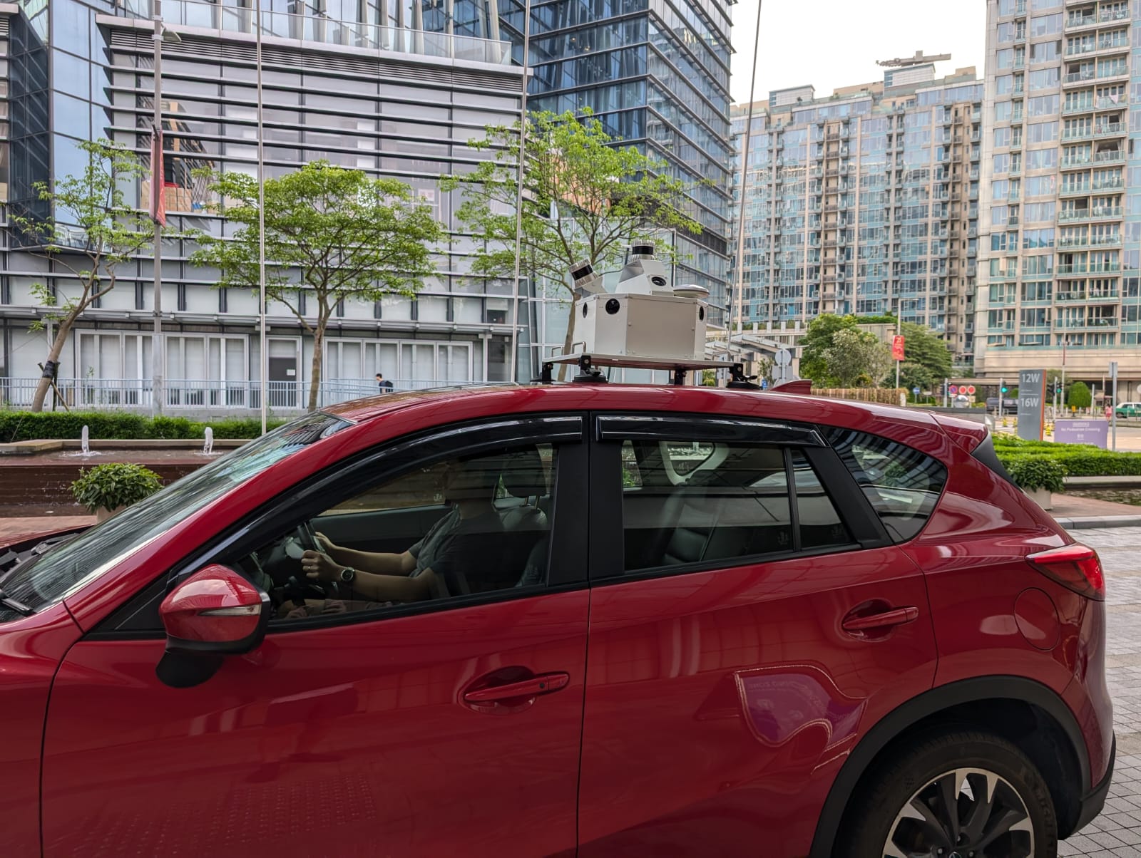
Mobile Mapping System
With SS360 MMS, you can capture high-resolution data without disrupting traffic. Our system uses LiDAR and IoT for precise mapping of highways and railways, providing critical insights for infrastructure management.

Tree Guard :
Vegetation Management SystemTreeGuard automatically scans for vegetation encroachment into the rail corridor. It provides detailed 3D models of the rail corridor for accurate analysis.

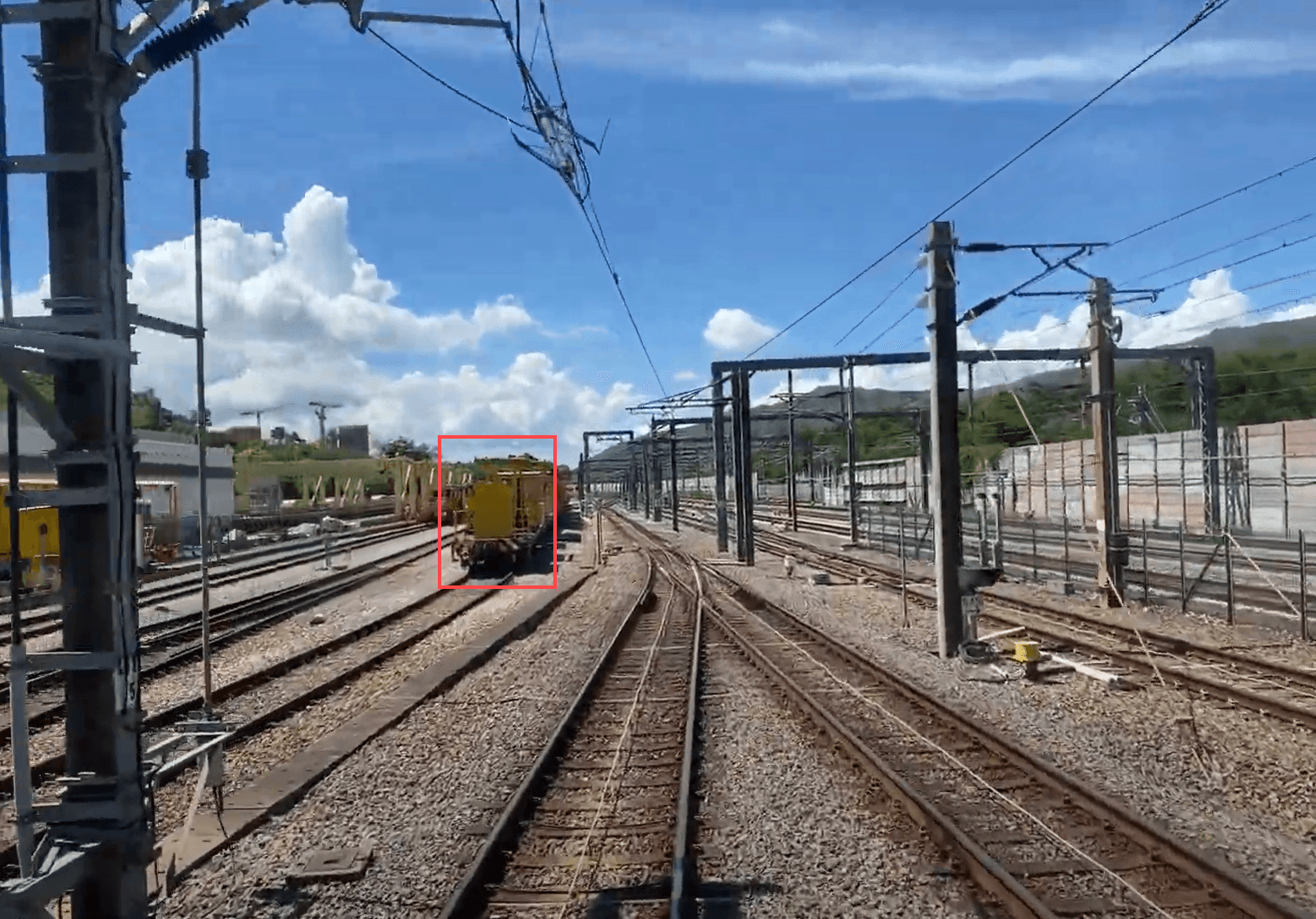
Track Vision :
Train Perception SystemThe system’s advanced automatic obstacle detection continuously scans the tracks for potential hazards, alerting drivers in real time. This proactive feature minimizes collision risks, enhancing safety and ensuring smoother operations.

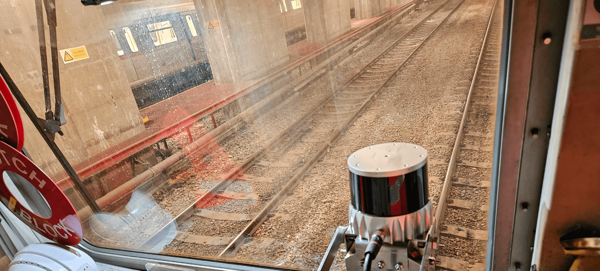
Ballast Vue :
Ballast Profile MonitoringBallastVue combines advanced LiDAR and camera fusion to generate real-time 3D models of track ballast. This technology ensures optimal distribution and stability, enhancing overall track performance.

Mobile Mapping System
With SS360 MMS, you can capture high-resolution data without disrupting traffic. Our system uses LiDAR and IoT for precise mapping of highways and railways, providing critical insights for infrastructure management.

Tree Guard :
Vegetation Management SystemTreeGuard automatically scans for vegetation encroachment into the rail corridor. It provides detailed 3D models of the rail corridor for accurate analysis.

Track Vision :
Train Perception SystemThe system’s advanced automatic obstacle detection continuously scans the tracks for potential hazards, alerting drivers in real time. This proactive feature minimizes collision risks, enhancing safety and ensuring smoother operations.

Ballast Vue :
Ballast Profile MonitoringBallastVue combines advanced LiDAR and camera fusion to generate real-time 3D models of track ballast. This technology ensures optimal distribution and stability, enhancing overall track performance.

Mobile Mapping System
With SS360 MMS, you can capture high-resolution data without disrupting traffic. Our system uses LiDAR and IoT for precise mapping of highways and railways, providing critical insights for infrastructure management.

Tree Guard :
Vegetation Management SystemTreeGuard automatically scans for vegetation encroachment into the rail corridor. It provides detailed 3D models of the rail corridor for accurate analysis.

Track Vision :
Train Perception SystemThe system’s advanced automatic obstacle detection continuously scans the tracks for potential hazards, alerting drivers in real time. This proactive feature minimizes collision risks, enhancing safety and ensuring smoother operations.

Ballast Vue :
Ballast Profile MonitoringBallastVue combines advanced LiDAR and camera fusion to generate real-time 3D models of track ballast. This technology ensures optimal distribution and stability, enhancing overall track performance.

Mobile Mapping System
With SS360 MMS, you can capture high-resolution data without disrupting traffic. Our system uses LiDAR and IoT for precise mapping of highways and railways, providing critical insights for infrastructure management.

Tree Guard :
Vegetation Management SystemTreeGuard automatically scans for vegetation encroachment into the rail corridor. It provides detailed 3D models of the rail corridor for accurate analysis.

Track Vision :
Train Perception SystemThe system’s advanced automatic obstacle detection continuously scans the tracks for potential hazards, alerting drivers in real time. This proactive feature minimizes collision risks, enhancing safety and ensuring smoother operations.

Ballast Vue :
Ballast Profile MonitoringBallastVue combines advanced LiDAR and camera fusion to generate real-time 3D models of track ballast. This technology ensures optimal distribution and stability, enhancing overall track performance.
Scanning
Scanning
Our state-of-the-art sensors are engineered for versatility, performing seamlessly across diverse environments, from busy airports to isolated construction sites.
Our state-of-the-art sensors are engineered for versatility, performing seamlessly across diverse environments, from busy airports to isolated construction sites.
Data Analysis
Data Analysis
Once the data is captured, it undergoes rigorous analysis through our proprietary algorithms.
Once the data is captured, it undergoes rigorous analysis through our proprietary algorithms.


Actionable Insights
Actionable Insights
The final step involves translating raw data into intuitive insights accessible through our user-friendly SaaS platform.
The final step involves translating raw data into intuitive insights accessible through our user-friendly SaaS platform.
Use Cases
Use Cases
Industrial Applications
Industrial Applications
Evaluating the effect of our solutions in the field of industry

Mobile Mapping System
With SS360 MMS, you can capture high-resolution data without disrupting traffic. Our system uses LiDAR and IoT for precise mapping of highways and railways, providing critical insights for infrastructure management.

Tree Guard : Vegetation Management System
TreeGuard automatically scans for vegetation encroachment into the rail corridor. It provides detailed 3D models of the rail corridor for accurate analysis.

Track Vision : Train Perception System
The system’s advanced automatic obstacle detection continuously scans the tracks for potential hazards, alerting drivers in real time. This proactive feature minimizes collision risks, enhancing safety and ensuring smoother operations.

Ballast Vue : Ballast Profile Monitoring
BallastVue combines advanced LiDAR and camera fusion to generate real-time 3D models of track ballast. This technology ensures optimal distribution and stability, enhancing overall track performance.

Mobile Mapping System
With SS360 MMS, you can capture high-resolution data without disrupting traffic. Our system uses LiDAR and IoT for precise mapping of highways and railways, providing critical insights for infrastructure management.

Tree Guard : Vegetation Management System
TreeGuard automatically scans for vegetation encroachment into the rail corridor. It provides detailed 3D models of the rail corridor for accurate analysis.

Track Vision : Train Perception System
The system’s advanced automatic obstacle detection continuously scans the tracks for potential hazards, alerting drivers in real time. This proactive feature minimizes collision risks, enhancing safety and ensuring smoother operations.

Ballast Vue : Ballast Profile Monitoring
BallastVue combines advanced LiDAR and camera fusion to generate real-time 3D models of track ballast. This technology ensures optimal distribution and stability, enhancing overall track performance.

Mobile Mapping System
With SS360 MMS, you can capture high-resolution data without disrupting traffic. Our system uses LiDAR and IoT for precise mapping of highways and railways, providing critical insights for infrastructure management.

Tree Guard : Vegetation Management System
TreeGuard automatically scans for vegetation encroachment into the rail corridor. It provides detailed 3D models of the rail corridor for accurate analysis.

Track Vision : Train Perception System
The system’s advanced automatic obstacle detection continuously scans the tracks for potential hazards, alerting drivers in real time. This proactive feature minimizes collision risks, enhancing safety and ensuring smoother operations.

Ballast Vue : Ballast Profile Monitoring
BallastVue combines advanced LiDAR and camera fusion to generate real-time 3D models of track ballast. This technology ensures optimal distribution and stability, enhancing overall track performance.

Mobile Mapping System
With SS360 MMS, you can capture high-resolution data without disrupting traffic. Our system uses LiDAR and IoT for precise mapping of highways and railways, providing critical insights for infrastructure management.

Tree Guard : Vegetation Management System
TreeGuard automatically scans for vegetation encroachment into the rail corridor. It provides detailed 3D models of the rail corridor for accurate analysis.

Track Vision : Train Perception System
The system’s advanced automatic obstacle detection continuously scans the tracks for potential hazards, alerting drivers in real time. This proactive feature minimizes collision risks, enhancing safety and ensuring smoother operations.

Ballast Vue : Ballast Profile Monitoring
BallastVue combines advanced LiDAR and camera fusion to generate real-time 3D models of track ballast. This technology ensures optimal distribution and stability, enhancing overall track performance.

Mobile Mapping System
With SS360 MMS, you can capture high-resolution data without disrupting traffic. Our system uses LiDAR and IoT for precise mapping of highways and railways, providing critical insights for infrastructure management.

Tree Guard : Vegetation Management System
TreeGuard automatically scans for vegetation encroachment into the rail corridor. It provides detailed 3D models of the rail corridor for accurate analysis.

Track Vision : Train Perception System
The system’s advanced automatic obstacle detection continuously scans the tracks for potential hazards, alerting drivers in real time. This proactive feature minimizes collision risks, enhancing safety and ensuring smoother operations.

Ballast Vue : Ballast Profile Monitoring
BallastVue combines advanced LiDAR and camera fusion to generate real-time 3D models of track ballast. This technology ensures optimal distribution and stability, enhancing overall track performance.

Mobile Mapping System
With SS360 MMS, you can capture high-resolution data without disrupting traffic. Our system uses LiDAR and IoT for precise mapping of highways and railways, providing critical insights for infrastructure management.

Tree Guard : Vegetation Management System
TreeGuard automatically scans for vegetation encroachment into the rail corridor. It provides detailed 3D models of the rail corridor for accurate analysis.

Track Vision : Train Perception System
The system’s advanced automatic obstacle detection continuously scans the tracks for potential hazards, alerting drivers in real time. This proactive feature minimizes collision risks, enhancing safety and ensuring smoother operations.

Ballast Vue : Ballast Profile Monitoring
BallastVue combines advanced LiDAR and camera fusion to generate real-time 3D models of track ballast. This technology ensures optimal distribution and stability, enhancing overall track performance.

Mobile Mapping System
With SS360 MMS, you can capture high-resolution data without disrupting traffic. Our system uses LiDAR and IoT for precise mapping of highways and railways, providing critical insights for infrastructure management.

Tree Guard : Vegetation Management System
TreeGuard automatically scans for vegetation encroachment into the rail corridor. It provides detailed 3D models of the rail corridor for accurate analysis.

Track Vision : Train Perception System
The system’s advanced automatic obstacle detection continuously scans the tracks for potential hazards, alerting drivers in real time. This proactive feature minimizes collision risks, enhancing safety and ensuring smoother operations.

Ballast Vue : Ballast Profile Monitoring
BallastVue combines advanced LiDAR and camera fusion to generate real-time 3D models of track ballast. This technology ensures optimal distribution and stability, enhancing overall track performance.

Mobile Mapping System
With SS360 MMS, you can capture high-resolution data without disrupting traffic. Our system uses LiDAR and IoT for precise mapping of highways and railways, providing critical insights for infrastructure management.

Tree Guard : Vegetation Management System
TreeGuard automatically scans for vegetation encroachment into the rail corridor. It provides detailed 3D models of the rail corridor for accurate analysis.

Track Vision : Train Perception System
The system’s advanced automatic obstacle detection continuously scans the tracks for potential hazards, alerting drivers in real time. This proactive feature minimizes collision risks, enhancing safety and ensuring smoother operations.

Ballast Vue : Ballast Profile Monitoring
BallastVue combines advanced LiDAR and camera fusion to generate real-time 3D models of track ballast. This technology ensures optimal distribution and stability, enhancing overall track performance.
Tech Specs
Tech Specs
Tech Specs
SE-64 Spatial Sense Edge
SE-64 Spatial Sense Edge
SE-64 Spatial Sense Edge
Integrates advanced processing capabilities with data from LiDAR sensors and high-resolution cameras to deliver real-time, 3D imaging of infrastructure environments.
Integrates advanced processing capabilities with data from LiDAR sensors and high-resolution cameras to deliver real-time, 3D imaging of infrastructure environments.


Processing Power
Processing Power
Processing Power
Memory
Memory
Memory
64Gb LPDDR5, 256-bit, 204.8 GB/s
64Gb LPDDR5, 256-bit, 204.8 GB/s
64Gb LPDDR5, 256-bit, 204.8 GB/s
CPU
CPU
CPU
8 cores, 2 Cortex-A78AE clusters (4 cores each), 2.2 GHz
8 cores, 2 Cortex-A78AE clusters (4 cores each), 2.2 GHz
8 cores, 2 Cortex-A78AE clusters (4 cores each), 2.2 GHz
CUDA Core
CUDA Core
CUDA Core
1792
1792
1792
Tensor Cores
Tensor Cores
Tensor Cores
56
56
56
Sparse TOPS
Sparse TOPS
Sparse TOPS
108 (939 MHz), 200 INT8 Sparse TOPS
108 (939 MHz), 200 INT8 Sparse TOPS
108 (939 MHz), 200 INT8 Sparse TOPS
NVDLA Engines
NVDLA Engines
NVDLA Engines
2 x v2.0, 1.4 GHz, 46 TOPS each
2 x v2.0, 1.4 GHz, 46 TOPS each
2 x v2.0, 1.4 GHz, 46 TOPS each
Video Capabilities
Video Capabilities
Video Capabilities
Video Encode
Video Encode
Video Encode
2 x 4K60, 4 x 4K30, 8 x 1080p60 (H.265)
2 x 4K60, 4 x 4K30, 8 x 1080p60 (H.265)
2 x 4K60, 4 x 4K30, 8 x 1080p60 (H.265)
Video Decode
Video Decode
Video Decode
1 x 8K30, 3 x 4K60, 6 x 4K30, 12 x 1080p60 (H.265)
1 x 8K30, 3 x 4K60, 6 x 4K30, 12 x 1080p60 (H.265)
1 x 8K30, 3 x 4K60, 6 x 4K30, 12 x 1080p60 (H.265)
Software Support
Software Support
Software Support
APIs
APIs
APIs
OpenGL 4.6+, OpenGL ES 3.2, Vulkan 1.2+, CUDA 10.2+
OpenGL 4.6+, OpenGL ES 3.2, Vulkan 1.2+, CUDA 10.2+
OpenGL 4.6+, OpenGL ES 3.2, Vulkan 1.2+, CUDA 10.2+
Jetpack
Jetpack
Jetpack
NVIDIA® JetPack 5.1.1
NVIDIA® JetPack 5.1.1
NVIDIA® JetPack 5.1.1
Storage
Storage
Storage
Flash Storage
Flash Storage
Flash Storage
64GB eMMC 5.1, 200 MHz
64GB eMMC 5.1, 200 MHz
64GB eMMC 5.1, 200 MHz
SD Card Slot
SD Card Slot
SD Card Slot
1 x SDXC-I/UHS-I
1 x SDXC-I/UHS-I
1 x SDXC-I/UHS-I
M.2 Slot
M.2 Slot
M.2 Slot
1 x 2280 Key M (PCIe 4.0 x4), NVMe SSD
1 x 2280 Key M (PCIe 4.0 x4), NVMe SSD
1 x 2280 Key M (PCIe 4.0 x4), NVMe SSD
Expansion
Expansion
Expansion
mPCIe Socket
mPCIe Socket
mPCIe Socket
1 x full size (PCIe 4.0, USB 2.0)
1 x full size (PCIe 4.0, USB 2.0)
1 x full size (PCIe 4.0, USB 2.0)
M.2 Key B Socket
M.2 Key B Socket
M.2 Key B Socket
1 x (USB 3.2/2.0), 2 x Nano SIM slots
1 x (USB 3.2/2.0), 2 x Nano SIM slots
1 x (USB 3.2/2.0), 2 x Nano SIM slots
M.2 Key E Socket
M.2 Key E Socket
M.2 Key E Socket
1 x (PCIe 4.0, USB 2.0) for Wi-Fi 5/6
1 x (PCIe 4.0, USB 2.0) for Wi-Fi 5/6
1 x (PCIe 4.0, USB 2.0) for Wi-Fi 5/6
Display
Display
Display
HDMI Output
HDMI Output
HDMI Output
1 x HDMI 2.0A/B, up to 3840 x 2160@60Hz
1 x HDMI 2.0A/B, up to 3840 x 2160@60Hz
1 x HDMI 2.0A/B, up to 3840 x 2160@60Hz
G- Sensors
G- Sensors
G- Sensors
Sensor
Sensor
Sensor
3D accelerometer and gyroscope (ST LSM6DSLTR)
3D accelerometer and gyroscope (ST LSM6DSLTR)
3D accelerometer and gyroscope (ST LSM6DSLTR)
Product Information Hub
Product Information Hub
Frequently Asked Questions
Frequently Asked Questions
Frequently Asked Questions
What is the technology behind SpatialSense?
Is a specific processing device required for the scanner?
How robust is the SpatialSense hardware?
Are there any specific installation requirements for SpatialSense?
What data can I get from SpatialSense?
Schedule a Meeting With Our Sales Team
Find out how SpatialSense can help transform your business.